Search Results
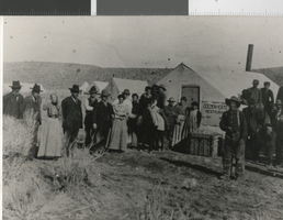
Photograph of Main Street in Palmetto (Nev.), 1906
Date
1906
Archival Collection
Description
Main Street, Palmetto, Esmeralda County, Nevada, 1906. There is an inscription on the back of the image: "Located 12 miles west of Lida, Nevada, Paletto was founded in 1866 after the discovery of silver in the area. The camp died and was reborn several times, the last of which was in 1906. Palmetto was named after the local joshua which its founders mistakenly thought was a relative of the palm tree. The district's mine eventually produced over $6,000,000. Nevada Historical Society Collection." There is a date stamp: mid-year 1986. Street Address: Main Street
Image
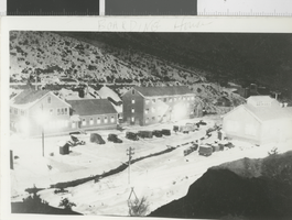
Photograph of Treadwell-Yukon operation in Tybo (Nev.), 1930
Date
1930-12
Archival Collection
Description
Treadwell-Yukon Co. Operation, Tybo, Nevada, December, 1930. There is a date stamp: Christmas, 1977.
Image
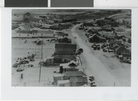
Photograph of Main Street in Silver Peak (Nev.), 1938
Date
1938
Archival Collection
Description
Main Street, Silver Peak, Nevada, 1938. There is an inscription on the back of the image: "In 1938, Silver Peak was Esmeralda County's largest and most prosperous town, boasting a population of over 1,000. The economy was supported chiefly by the nearby mines of the Nivloc and Mary Mine areas. The town's prosperity ended when the mines closed with the beginning of WWII." The section of town in the upper left corner of the photo, which included the post office, several stores and a theater was destroyed by fire in 1948. There is a date stamp: Christmas, 1986.
Image
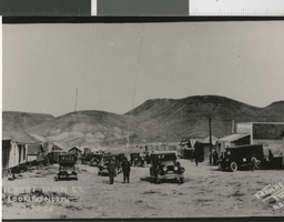
Photograph of Gilbert (Nev.), 1925
Date
1925-02-25
Archival Collection
Description
Gilbert, Nevada, February 25, 1925. Gilbert was located in the Monte Cristo Range, 26 miles west of Tonopah. There is an inscription on the back of the image: "The town was founded as the result of a rich gold strike in the area by the Gilbert brothers in 1924. At its height (1925-1927), the town's population exceeded 400. After the boom, the mines maintained a small, steady production until World War II eventually forced them to close. In addition to gold, the district produced lead, silver and high grade turquoise. Nevada Historical Society Collection." There is a date stamp: 1987.
Image
Photograph of 1200 foot level, Belmont Mine in Tonopah (Nev.), 1911
Date
1911
Archival Collection
Description
1200 ft. level, Belmont Mine, Tonopah, NV, 1911. There is an inscription on the back of the image: "The Tonopah Belmont Development Company was Tonopah's second most prosperous mining company, recording a production of $38,000,000. The Belmont mine was the company's principal working shaft and reached a depth of 1700 feet. The Belmont shaft was in use from 1909 until it was burned out by a fire of undetermined origin October 31, 1939." There is a date stamp: mid-year 1987.
Image
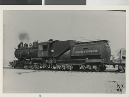
Photograph of Engine #8 of the Tonopah and Tidewater Railroad in Beatty (Nev.), circa 1934
Date
1934 to 1936
Archival Collection
Description
There was an inscription on the image. "This photo was taken in Beatty, Nevada in the mid-1930s. Engine #8 of the Tonopah and Tidewater Railroad can be seen idling in the railroad yards. The Tonopah and Tidewater was one of the three railroads serving Beatty during the Rhyolite mining boom of 1906-07. It was built in 1907 and ran until 1940. The tracks were removed in 1943. The other two lines were the Las Vegas and Tonopah Railroad (1906-1918) and the Bullfrog Goldfield Railroad (1906-1928). The Tonopah and Tidewater ran from Ludlow, CA to Goldfield, NV, although its rails only reached Beatty. The railroad used both L. V. and T.R.R. and B. G. R.R. track between Beatty and Goldfield. Engine #8 was a 2-8-0 Baldwin built for the T. & T. in 1907. The engine was sold to Kaiser Steel Company in 1944 when the T. & T. was abandoned. Kaiser rebuilt it and used it as a switcher until it was scrapped, probably in the 1950s."
Image
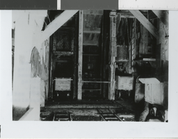
Photograph of the Black Mammoth Consolidated Mining Company's commissary, Mary Mine (Nev.), circa 1937
Date
1935 to 1937
Archival Collection
Description
There was an inscription on image. "#32. Black Mammoth Consolidated Mining Company commissary, Mary Mine, Nevada, ca. 1937. The Mary Mine is located five miles north of Silver Peak, Nev. and was developed by the Pittsburgh Silver Peak Gold Mining company between 1906 and 1916. The commissary was built in 1907. The mine was taken over by the Black Mammoth company in 1936 and operated until 1941. During this time the commissary, which housed a store, bar, entertainment center and boarding house, served over 150 men who worked at the mine. The Mary, a gold mine, produced over $7,800,000 between 1907 and 1941."
Image
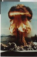
Photograph of atomic test Priscilla detonation, Nevada Test Site (Nev.), June 24, 1957
Date
1957-06-24
Archival Collection
Description
Atomic test "Priscilla" detonated at the Nevada Test Site in southern Nye County June 24, 1957. Priscilla was one of nearly one hundred atmospheric nuclear tests conducted at the site during the 1950s. Atmospheric testing was banned by treaty between the United States and the Soviet Union in 1963, although it had been moved underground in Nevada in 1959. Since 1951, more than 600 nuclear devices have been detonated at the Nevada Test Site.
Image
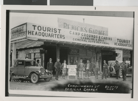
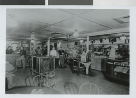
Photograph of Remick's Garage, Beatty (Nev.), circa 1930
Date
1929 to 1931
Archival Collection
Description
To the weary automobile traveler from the north or south, Beatty, and the garage, were probably welcome sights. The garage handled Union gasoline, oil, tires, and auto repairs in addition to being the area's Authorized Ford Service Station. It was also the town's "Tourist Headquarters" with campgrounds and cabins (forerunner of today's motels).
Image
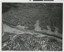
Aerial photograph of Little Fish Lake Valley (Nev.)
Date
1880 to 1982
Archival Collection
Description
Aerial View of upper Little Fish Lake Valley showing some of the planted grasses in the lower valleys and scattered pinyon/juniper along the slopes. (BLM photo by Bob Lund) (No exact date found)
Image