Search Results
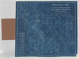
Prospectors map of Tonopah, Goldfield, Bull Frog, & principal mining districts
Date
1905
Description
Showing towns, roads, trails & watering places, in southern Nevada & Death Valley region, California. 1 map ; 44 x 49 cm, folded in cover 18 x 11 cm. Scale [1:950,400]. 15 mi. to an inch. (W 119⁰--W 114⁰/N 39⁰--36⁰). Relief shown by hachures. Blueprint. "Jan. 1905." Includes list of distances. Goldfield, Nev. : Booker, Philbrick & Fenner.
Image
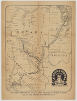
"Las Vegas & Tonopah Railroad - The Goldfield Route" map
Date
1910
Description
Map showing "Las Vegas & Tonopah Railroad 'The Goldfield Route.'" On the back it lists a timetable, railroad employees and executives, and descriptions of districts and towns: Johnnie, Beatty, Rhyolite, Bonnie Clare, Goldfield, Tonopah, Manhattan, Round Mountain, and Hornsilver.
Image

Extending Town Site
Date
1911
Archival Collection
Description
Series 1. San Pedro, Los Angeles and Salt Lake Railroad -- J. Ross Clark/Los Angeles Office Files
Mixed Content