Search Results
Sale of Las Vegas Land and Water Company To Water District, File number 2 (2 of 2)
Date
1954
Archival Collection
Description
Series 2. Las Vegas Land and Water Company -- Walter Bracken and the Las Vegas, Nevada Office -- Water Company
Mixed Content

Purchase and sale of land - general
Date
1908 to 1954
Archival Collection
Description
Series 2. Las Vegas Land and Water Company -- Walter Bracken and the Las Vegas, Nevada Office -- Railroad Files
Mixed Content
LVLWC - proposed sale of water production facilities of UPRRC (1 of 2)
Date
1952 to 1953
Archival Collection
Description
Series 2. Las Vegas Land and Water Company -- General Manager, Manager of Properties, and Manager of Industrial Development in Los Angeles, California -- Las Vegas Land and Water Company (LVLWC) Corporate Documents, Reports, and Accounts
Mixed Content

LVLWC - proposed sale of water production facilities of UPRRC
Date
1952
Archival Collection
Description
Series 2. Las Vegas Land and Water Company -- General Manager, Manager of Properties, and Manager of Industrial Development in Los Angeles, California -- Las Vegas Land and Water Company (LVLWC) Corporate Documents, Reports, and Accounts
Mixed Content
LVLWC - sale of water production facilities of UPRRC
Date
1953 to 1954
Archival Collection
Description
Series 2. Las Vegas Land and Water Company -- General Manager, Manager of Properties, and Manager of Industrial Development in Los Angeles, California -- Las Vegas Land and Water Company (LVLWC) Corporate Documents, Reports, and Accounts
Mixed Content

LVLWC - sale of water production facilities of UPRRC (1 of 2)
Date
1954
Archival Collection
Description
Series 2. Las Vegas Land and Water Company -- General Manager, Manager of Properties, and Manager of Industrial Development in Los Angeles, California -- Las Vegas Land and Water Company (LVLWC) Corporate Documents, Reports, and Accounts
Mixed Content
LVLWC - sale of water production facilities of UPRRC
Date
1954
Archival Collection
Description
Series 2. Las Vegas Land and Water Company -- General Manager, Manager of Properties, and Manager of Industrial Development in Los Angeles, California -- Las Vegas Land and Water Company (LVLWC) Corporate Documents, Reports, and Accounts
Mixed Content
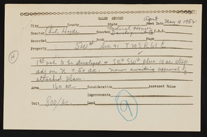
LVVWD - Sales Information - for testimony at Carson City hearing
Date
1947 to 1952
Archival Collection
Description
Series 9. Land and Tax -- Correspondence
Mixed Content
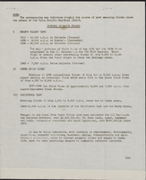
History of major floods in Moapa valley and adjacent washes, after 1945
Date
1945 (year approximate) to open end
Archival Collection
Description
List of the major floods in the Moapa Valley with map to show locations of the floods.
Text
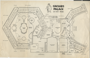
Map of Caesars Palace buildings, circa 1969
Date
1969 (year approximate)
Archival Collection
Description
Labeled map of the original buildings of Caesars Palace resort, hotel, and casino.
Image