Search Results
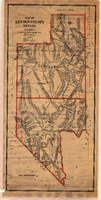
Map of Lincoln County (Nev.), 1908
Date
1908
Description
Scale [ca. 1:380,160]. 1 in. to approx. 6 miles (W 116 --W 114 /N 39 --N 35 ) ; 1 map : hand col., mounted on linen ; 115 x 54 cm ; Relief shown by hachures and spot heights ; Hand colored ; Shows range and township grid ; Shows towns, railroads, proposed railroads, wagon roads and springs ;
Image

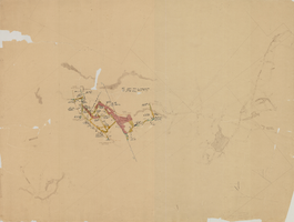
Map of the Red Top Mine, 4th level, Esmeralda County (Nev.), 1900-1925
Date
1900 to 1925
Description
Sectional mining map; hand-drawn and annotated in colored pencil
Image
Map of the Combination Mine, 280 ft., Esmeralda County (Nev.), 1900-1925
Date
1900 to 1925
Description
Sectional mining map; hand-drawn and annotated in colored pencil
Image
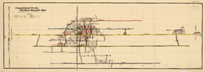
Map of the Longitudinal Section, Montana Tonopah Mine, Nye County (Nev.), 1900-1925
Date
1900 to 1925
Description
Map of the Longitudinal Section, Montana Tonopah Mine, Nye County (Nev.), 1900-1925
Image
Appraisal and valuation of lots
Date
1907 to 1931
Archival Collection
Description
Series 2. Las Vegas Land and Water Company -- Walter Bracken and the Las Vegas, Nevada Office -- Water Company
Mixed Content
Water Conservation - supply from Lake Mead (2 of 2)
Date
1944 to 1953
Archival Collection
Description
Series 2. Las Vegas Land and Water Company -- Walter Bracken and the Las Vegas, Nevada Office -- Water Company
Mixed Content
Water Service Rates
Date
1909 to 1950
Archival Collection
Description
Series 2. Las Vegas Land and Water Company -- Walter Bracken and the Las Vegas, Nevada Office -- Water Company
Mixed Content
Water Service Rates - new schedule
Date
1949 to 1951
Archival Collection
Description
Series 2. Las Vegas Land and Water Company -- Walter Bracken and the Las Vegas, Nevada Office -- Water Company
Mixed Content
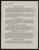
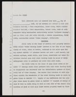
Sale of Las Vegas Land and Water Company To Water District, File number 1 (2 of 2)
Date
1952 to 1954
Archival Collection
Description
Series 2. Las Vegas Land and Water Company -- Walter Bracken and the Las Vegas, Nevada Office -- Water Company
Mixed Content
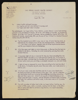
Sale of Las Vegas Land and Water Company To Water District, File number 2 (1 of 2)
Date
1954
Archival Collection
Description
Series 2. Las Vegas Land and Water Company -- Walter Bracken and the Las Vegas, Nevada Office -- Water Company
Mixed Content