Search Results
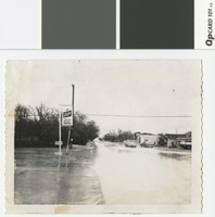
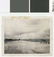
Photograph of flooded street corner in Vegas Heights, Nevada, 1964
Date
Archival Collection
Description
Flooding at Lexington and Miller in Vegas Heights. Flooding due to lack of sewers and drainage. There is some residue at bottom of photo.
Transcribed Notes: Sign on photo reads: Schlitz. Anna & Bob Bailey's Sugar Hill
Image
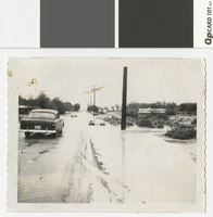
Photograph of flooding in Vegas Heights, Nevada, 1964
Date
Archival Collection
Description
Flooding at Balzar and Lasalle in Vegas Heights. Flooding due to lack of sewers and drainage. There is some residue on photo.
Image
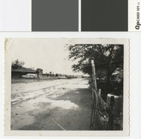
Photograph of flooded street in Vegas Heights, Nevada, 1964
Date
Archival Collection
Description
Flooding at Hassell and Highland in Vegas Heights after a rain storm. There is some residue on photo.
Transcribed Notes: Notes on attached sheet: Vegas Hts., 1964 - Hassell & Highland. Streets flooded during severe rain - no sewers or drainage.
Image
Photograph of flooded residential area in Vegas Heights, Nevada, 1964
Date
Archival Collection
Description
Flooding at Lexington and Carey in Vegas Heights after a severe rain storm. There are spots of residue on photo.
Image
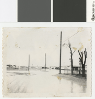
Photograph of flooding on road in Vegas Heights, Nevada, 1964
Date
Archival Collection
Description
Flooding at Revere and Hart Streets in the newly annexed Vegas Heights. There is residue on top border of photo.
Transcribed Notes: Notes on attached sheet: Vegas Heights (1964) - Revere & Hart Streets. Newly annexed part of Las Vegas - no sewers or proper drainage.
Image

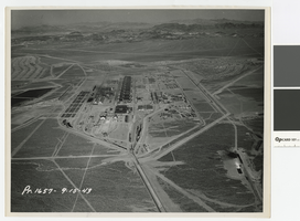
Aerial photograph of Basic Magnesium Incorporated facility, southward direction, Henderson, Nevada, September 15, 1943
Date
Archival Collection
Description
Aerial view of Basic Magnesium plant from the north
Image
Aerial photograph of Basic Magnesium Incorporated facility, eastward direction, Henderson, Nevada, September 15, 1943
Date
Archival Collection
Description
Aerial view of Basic Magnesium plant from the west
Image
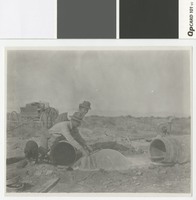
Photograph of William S. and Mary Belle Park near an artesian well, circa 1910
Date
Archival Collection
Description
William S. and Mary Belle Park[?] near an artesian well.
Transcribed Notes: Handwritten on back: Mrs. W. S. Park
Image
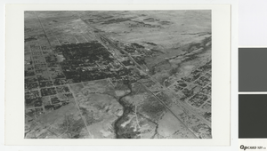
Aerial photograph of Las Vegas, 1931
Date
Archival Collection
Description
Aerial view of Las Vegas looking southwest
Transcribed Notes: Notes from photo sleeve: "Aerial view of Las Vegas, Nevada, 1931. At left center is Clark Townsite; at right edge is McWilliams Townsite."
Image
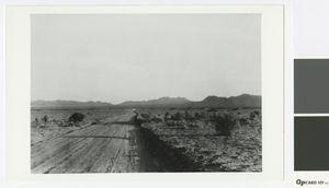
Photograph of Boulder Highway looking southeast towards Railroad Pass, 1931
Date
Archival Collection
Description
Boulder Highway looking southeast towards Railroad Pass.
Transcribed Notes: Notes from photo sleeve: "Boulder (Nevada) Highway in the vicinity of what is now East Las Vegas. The view is looking south toward Railroad Pass. (early 1931)"
Image