Search Results
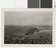
Photograph looking west over the Colorado River and Hemenway Wash from Fortification Hill, before 1931
Date
Archival Collection
Description
Looking west over the Colorado River and Hemenway Wash from Fortification Hill.
Transcribed Notes: Handwritten collection note on back of photo: [Las Vegas Wash and area under water now(?)]; Notes on photo sleeve: [Las Vegas Wash area] from top of Fortification Mountain. (Credit: W.A. Davis); 'Wint made a fire at night on top then kicked it off into space. Lacey hired Wint to do it for some tourists.' - James J. Hester, son-in-law of W.A. ('Wint') Davis, 1992
Image
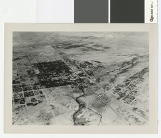
Aerial photograph of Las Vegas, partial view of high school, southwest direction, 1930
Date
Archival Collection
Description
Aerial view of Las Vegas in 1930
Transcribed Notes: Handwritten collection note on back of photo: Aerial view of Las Vegas showing Fifth St. and Main St., c. 1933; Notes on photo sleeve: Aerial view of Las Vegas 'taken in a clip wing Jenny. Date is winter of 1930. Plane had a wooden propeller open cockpit. Pilot had a contract with Bureau of Reclamation to fly aerial photos in a grid. Took Wint (up in) the plane this day because it was too windy (for the pilot) to take his regular aerials.' (James J. Hester, son-in-law of W.A. Davis ('Wint'), the photographer who took this. Note added 4-92.
Image
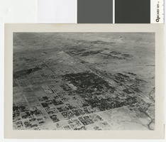
Aerial photograph of Las Vegas, full view of high school, southwest direction, 1930
Date
Archival Collection
Description
Aerial view of Las Vegas in 1930
Transcribed Notes: Notes on back of duplicate photo: Aerial view of Las Vegas w/ new high school on bottom left, c. 1933; Notes on photo sleeve: Aerial view of Las Vegas taken in the winter of 1930 (same day as #0123 002) in clip wing Jenny. Shows railroad and main street - essentially shows the whole city. (Credit: W.A. Davis)
Image

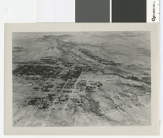
Aerial photograph of Las Vegas looking south, 1930
Date
Archival Collection
Description
Aerial view of Las Vegas in 1930.
Transcribed Notes: Notes on photo sleeve: 'Shows stockyards and car shops. Creek is overflow from UP artesian well. Site of earliest ranch in area. Creek had mosquito minnows in it - a native species. Only source of water for Las Vegas. Water carried in a 20-24'' wooden pipe.' (James J. Hester, from W.A. Davis, photographer. April 1992)
Image
Aerial photograph of Las Vegas looking west, 1930
Date
Archival Collection
Description
Aerial view of Las Vegas in 1930
Transcribed Notes: Notes on photo sleeve: Aerial view of Las Vegas, probably winter of 1930. (Credit: W.A. Davis)
Image
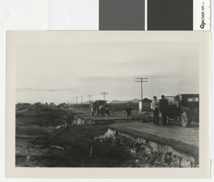
Photograph of road washout five miles southeast of Las Vegas, circa 1931
Date
Archival Collection
Description
Washout at 4-mile on the Boulder Highway, about 5 miles southeast of Las Vegas.
Transcribed Notes: Notes on photo sleeve: 'New pavement finished in May. Cloudburst in October took out culvert. Took out a Chevrolet and a Packard. About 5 mi. southeast of Las Vegas.' (James J. Hester, quote from W.A. Davis)
Image

Photograph of cars overturned by a 4 mile cloudburst flood, circa 1931
Date
Archival Collection
Description
Car overturned by flood at 4-mile on the Boulder Highway, about 5 miles southeast of Las Vegas
Transcribed Notes: Handwritten collection note on back of photo: Cars overturned by cloudburst flood near wash by present-day Showboat. c. 1931-1932; Notes on photo sleeve: 'Photo taken at night with flash. Probably Chevrolet wrecked in flood in Vegas Wash. Water was 4 ft. deep on pavement.' (W.A. Davis, photographer)
Image

Photograph of a grinding slab metate at the Lost City, Clark County, before 1938
Date
Archival Collection
Description
Grinding slab metate at the Lost City with numerous holes
Transcribed Notes: Notes on photo sleeve Los City, Nevada. Holes and stones were used to grind grains, etc. (Credit: W.A. Davis); 'Gypsum Cave, bedrock mortars near cave' - W.A. Davis
Image

Photograph of water storage tank construction in Boulder City, circa 1931
Date
Archival Collection
Description
Construction of a water tank in Boulder City by the Clearfire Water Company.
Transcribed Notes: Notes on photo sleeve: 'Hill leveled with dynamite before building tank - Clearfire Water Co. Water came into booster plant from river. Dumps at river were on inclined steel rails and went up and down with water level. Then went from booster plant to clarification station, then on to this storage tank.' (W.A. Davis)
Image
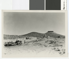
Photograph of leveling sand dunes west of the water tower in Boulder City, circa 1931
Date
Archival Collection
Description
Bulldozers leveling sand dunes west of the water tower in Boulder City.
Image