Search Results

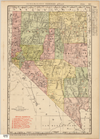
Map showing railroads in Nevada, 1911
Date
1911
Description
Relief shown by hachures. Title below scale: Rand McNally & Co.'s New business atlas map of Nevada. Shows railroads. Includes township and range grid. Includes index to principal cities with population statistics. Includes township and range grid. Index to Nevada counties, lakes, mountains, rivers, towns, etc. on verso. Published by Rand McNally & Co. Scale [ca. 1,710,720]. 1 in. = 27 miles (W 120°--W 114°/N 42°--N 35°). Published as page 321 of Rand-McNally indexed atlas.
Text
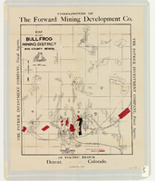
Map of the Bullfrog Mining District, Nye County, Nevada, circa 1905
Date
1901 to 1909
Description
At top of map: 'Compliments of the Forward Mining Development Co.' On left and right margins: 'The Patrick Investment Company, Fiscal Agents.' At bottom of map: '19 Toltec Block, Denver, Colorado.' 'The Williamson-Haffner Co., Denver.' Relief shown by hachures. Properties owned by Patrick Investment Company are marked in red. Shows railroads, roads, and pipelines. Scale [ca. 1:39,000. 1 in. to approx. 3,250 feet].
Image
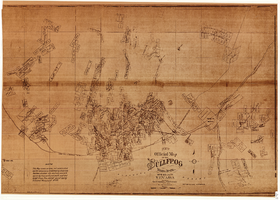
Map of the Bullfrog Mining District, Nye County, Nevada, circa 1905
Date
1901 to 1909
Description
'Compiled by Geo. E. Sherer and W.B. Milliken, miners and surveyors, Bull Frog, Nye Co., Nevada.' 'Photo. Lith. Britton & Rey, S.F.' Scale [ca. 1:16,800. 1 inch to approximately 1,400 feet]. Blueline print.
Image
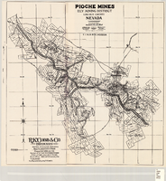
Map of Pioche mines, Ely Mining District, Lincoln County, Nevada, 1909
Date
1909
Description
'A.D. Knowlton, Mining Engineer, Pioche, Nevada; H.H. Snelgrove, Draftsman, Salt Lake City, Utah. Copyright 1909 Rufus K. Cobb.' Includes township and range grid; Includes wagon roads. Published by R.K. Cobb. Photocopy.
Image
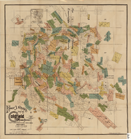
Map of the Goldfield Mining District, Nye and Esmeralda Counties, Nevada, 1905
Date
1905
Description
Copyright 1905 by Elmer J. Chute, E.M. Goldfield, Nev. In lower right corner: "Designed and drawn by R.W. Griswold." Includes inset location map; Includes township and range grid. Scale [ca. 1:20, 400. 1 in.=aprrox. 1,700 feet]
Image
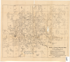
Map of U.S. patent and location surveys in the Goldfield Mining District, Esmeralda and Nye Counties, Nevada, 1907
Date
1907
Description
'Elmer J. Chute, E.M. and Olmstead & Rich. U.S. Deputy Mineral Surveyors, 1907. Copyright 1907 by Elmer J. Chute, E.M., Goldfield, Nev.' Includes index Includes township and range grid. Scale [ca. 1:22,800. 1 in. to approx. 1900 feet]
Text
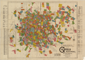
Map of the Goldfield Mining District, Goldfield, Nevada, 1907
Date
1907
Description
'Elmer J. Chute, E.M. and Olmstead and Rich, Goldfield, Nevada. Copyright 1907, by Elmer J. Chute, Goldfield, Nev.' Includes information on and prices for wall and pocket map with this title. Includes inset map. Includes township and range grid. Library's copy has Rochester GF. claim circled in blue ink , has a piece missing to the right of that claim, and has "Mohawk ledge, a lease by Davis & Shoemaker" written in blue ink at the center bottom of the map with a line in blue ink drawn to the Frances Mohawk claim.
Image

Map of Argentite Red Mountain Mining District, Esmeralda County, Nevada, circa 1908-1913
Date
1908 to 1913
Description
'Compiled by C. A. Liddell, U.S. Mineral Surveyor, Tonopah, Nevada, from surveys by Sherwin, Giles and Liddell.' Published between 1908-1913? Scale [ca. 1:7,200]. 1 in. equals 600 feet. Map printed on linen.
Image