Search Results

Map showing second stage plan of development for Southern Nevada Water Project, March 1981
Date
1981-03
Description
'United States Department of the Interior, Bureau of Reclamation.' 'June 1976. Revised March 1981.' 'Map No. 952-300-203.' 'Exhibit I.' Includes inset location map for project area. Scale [ca. 1:126,720. 1 in. to approx. 2 miles] . United States Department of the Interior, Bureau of Reclamation
Image
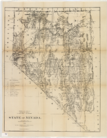
Map of Nevada, 1876
Date
1876
Description
'Compiled from the official records of the General Land Office and other sources by C. Roeser, principal draughtsman, G.L.O. Photo-lith & print. by Julius Bien, 16 & 18 Park Place, N.Y.' 'Department of the Interior, General Land Office, J.A. Williamson, Commissioner.' Scale [1:1,013,760]. 1 in. to 16 miles (W 120°--W 114°/N 42°--N 35°) .Relief shown by hachures. Shows township and range grid. Department of the Interior, General Land Office.
Image
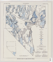
Tectonic map of Clark County, Nevada, 1965
Date
1965
Description
'Nevada Bureau of Mines. Bulletin 62, plate 5.' 'Prepared cooperatively by the U.S. Geological Survey.' Shows types of rocks as well as faults. Scale [ca. 1:760,320. 1 in. to approx. 12 miles] (W 116°--W 114°/N 37°--N 35°). Bulletin (Nevada Bureau of Mines)
62.
62.
Image
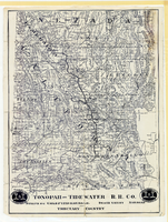
Map showing Tonopah & Tidewater Railroad Company line from Ludlow, California to Goldfield, Nevada, circa 1907
Date
1905 to 1909
Description
Scale not given. Relief shown by hachures and spot heights. Shows township and range grid. Shows mines, camps and ranches. Tonopah & Tidewater Railroad Company. Library's copy mounted on linen.
Image
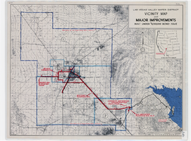
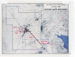
Map showing improvements made to the Las Vegas Valley Water District and vicinity under $8,700,000 bond issue,circa 1957
Date
1953 to 1961
Description
Relief shown by contour lines and spot heights. Includes inset location map of the Water District. Shows township and range grid. Boundary of Las Vegas Valley Water District marked in dark blue. 'Cole '57' in lower left corner. Scale [ca. 1:72,000. 1 in. to approx. 6,000 ft.]
Image
Map showing improvements made to the Las Vegas Valley Water District and vicinity, circa 1950
Date
1946 to 1954
Description
Relief shown by contour lines. Includes inset map showing the location of the Las Vegas Valley Water District Project. In lower left corner: 'Cole...O.' Boundary of Las Vegas Valley Water District marked in dark blue. Scale [ca. 1:126,720. 1 in. to approx. 2 miles
Image
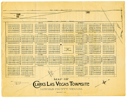
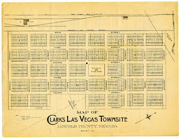
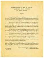
Map of Clark's Las Vegas Townsite, Lincoln County, Nevada, May 10, 1905
Date
1905-05-10
Archival Collection
Description
Scale: 1" = 100'. 1 map ; 28 x 22 cm. Verso of map is an announcement of the auction to be held May 15, 1905, for lots in the Las Vegas townsite. Pricing and lot information is included, as well as specials for railway tickets to Las Vegas from Los Angeles and Salt Like City. Las Vegas Land and Water Company
Text

Map of California, and territories of Utah, Nevada, Colorado, New Mexico and Arizona, 1864
Date
1864
Description
'Johnson's California, also Utah, Nevada, Colorado, New Mexico, and Arizona, published by A.J. Johnson, New York.' 'Entered according to act of Congress in the year 1864, by A.J. Johnson in the Clerks Office of the District Court of the United States for the southern district of New York.' Atlas page numbers in upper margin: 67-68. Relief shown by hachures. Prime meridian: Greenwich and Washington. Shows natural features, locations of Indian tribes, proposed railroad routes, routes of explorers, trails, county boundaries and populated places. Hand colored. On verso: 'Historical and statistical view of the West India Islands or Columbian Archipelago' (p. 80) and 'Historical and statistical view of Mexico and Central America' (p. 79). Scale [ca. 1:3,484,800]. 1 in. to ca. 55 miles (W 124°--W 102°/N 42°--N 32°).
Text