Search Results
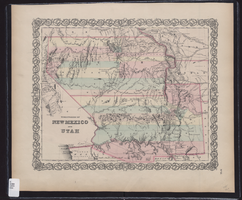
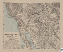
Map showing the territories of New Mexico and Utah, 1855
Date
1855
Description
'Entered according to Act of Congress in the year 1855 by J.H. Colton & Co. in the Clerk's Office of the Dist. Court of the U.S. for the South'n. Dist. of New York.' Scale [ca. 1:4,752,000. 1 in. to approx. 75 miles] (W 120°--W 102°/N 43°--N 32°). Shows natural features, and populated places, wagon route, proposed railroad routes and explorers' routes. Relief shown by hachures. Prime meridians: Greenwich and Washington.Hand colored. Atlas p. number in lower-right margin: 51. Decorative border. J.H. Colton & Co.
Image

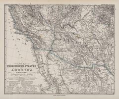
Map of California, with territories of Utah, Nevada, Colorado, New Mexico, and Arizona, 1864
Date
1864
Description
40 x 62 cm. Relief shown by hachures. Prime meridians: Greenwich and Washington. Page numbers at top: 58-59. "Entered according to act of Congress in the year 1864 by A. J. Johnson in the Clerk's Office of the District Court of the United States for the Southern District of New York." Original publisher: Johnson and Ward.
Image
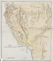
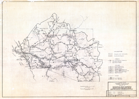
Map showing the different routes travelled over by the detachments of the Overland Command in the spring of 1855 from Salt Lake City, Utah, to the Bay of San Francisco, 1855
Date
1855
Description
57 x 47 cm., folded to 22 x 13 cm. Indicates routes of Capt. Ingalls, Col. Steptoe,and Lt. Mowrey, and shows camping grounds. Relief shown by hachures. Graphic scale given in geographical as well as statute miles. "Ackerman Lith. 319 Broadway, N.Y." Hand colored. Original publisher unknown, Series: House Ex. Doc. No. 1, 1st session, 34th Congress.
Image
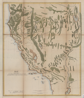
Map showing the different routes travelled over by the detachments of the Overland Command in the spring of 1855 from Salt Lake City, Utah, to the Bay of San Francisco, 1855
Date
1855
Description
57 x 47 cm. Indicates routes of Capt. Ingalls, Col. Steptoe, and Lt. Mowrey, and camping grounds. "Ackerman Lith. 319 Broadway, N.Y." Relief shown by hachures. In Wheat, "Mapping of the Trans-Mississippi West", v. 4, p. 210. Library's copy 1 is poor quality and not in color. Original publisher unknown, Series: Senate Ex. Doc. No. 1, 1st session, 34th Congress.
Image
Die Vereinigten Staaten von Amerika in 6 Blättern im Maassstabe von 1:3,700,000
Date
1882
Description
33 x 41 cm. Relief shown by hachures and spot heights. Prime meridian: Greenwich. Sheet 4 of a 6-sheet map. "Petermann: ver. st. v. am. bi. 4". "Stieler's Hand Atlas, No. 86." Binder's title of Hand Atlas über alle Thiele der Erde und über das Weltgebäude, which was published in 1879. In German. Library has only map of Arizona and parts of surrounding states and northern Mexico. Original publisher: Justus Perthes.
Image
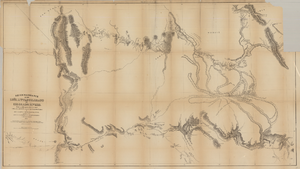
Map based on reconnaissance of the Zuñi, Little Colorado and Colorado Rivers in 1851 by U.S. Corps of Topographical Engineers
Date
1852
Description
Transcribed from the original: 'Made in 1851 under the direction of Col J.J. Abert, Chief of Corps Topographical Engineers, by BVT. Capt. L. Sitgreaves, T.E., assisted by Lieut. J.G. Parke, T.E., and Mr. M.H. Kern. Drawn by R.H. Kern, 1852.' 'Gila River from a reconnaissance by Maj. Emory, Topographical Engrs. Colorado River below Camp Yuma from a reconnaissance by Lt. Derby Topographical Engrs.' Shows Indian villages and forts. Upper right corner partially missing. Scale [ca. 1:650,000]. Scale of 10 miles to one inch.' 'Ackerman Lith.: 379 Broadway, N.Y.'
Image
Regional map showing main air, highway, bus and railroad transportation, October 30, 1945
Date
1945-10-30
Description
50 x 70 cm. Blue-line print. Shows Arizona, western New Mexico, southwestern Utah, southern Nevada, and southern California. Also shows irrigation projects constructed and under construction. "Oct. 30, 1945. Rev. 2-14-46." "Drawn and traced by F. R. M." Original publishser: Bureau of Reclamation, Region III.
Image
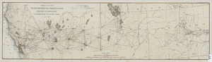
Map of the progress of the transcontinental triangulation and reconnaissance eastward from the Pacific Coast, June 30, 1883
Date
1883-06-30
Description
26 x 93 cm. "Coast and Geodetic Survey report, 1883, no. 23." "June 30, 1883." Original publisher: U.S. Coast and Geodetic Survey, Scale: 1: 2000 000.
Image
Map of Southwestern United States of America, 1888
Date
1888
Description
33 x 41 cm. Relief shown by hachures and spot heights. 1 sheet of a 6-sheet map. "Petermann: ver. st. v. am. bi. 4". "Stieler's Hand Atlas, No. 86." Binder's title of Hand Atlas über alle Thiele der Erde und über das Weltgebäude, which was published in 1879. In German. Revised 1889. "Neubearbeitret v. H. Habenicht." Original publisher: Justus Perthes, Scale: 1:3,700,000.
Image
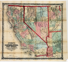
Bancroft's map of California, Nevada, Utah and Arizona, 1873
Date
1873
Description
Hand colored ; Relief shown by hachures and spot heights ; Prime meridian: Washington, D.C ; Shows railroads, proposed railroads and wagon roads, etc. Published by A.L. Bancroft & Company. Scale [ca. 1:1,520,640]. 1 in. to 24 miles (W 124°--W 111°/N 42°--N 32°).
Image