Search Results
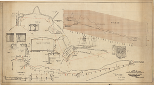
Map showing proposed improvements of Las Vegas Springs, Las Vegas, Nevada, January 26, 1918
Date
Archival Collection
Description
'Exhibit A'. 'Approved Jan. 26, 1918.' Includes discharge figures and plans for improvements to springs for the municipal water system including diagrams of spillway openings, etc. Scale [ca. 1:1200] 1 in.=100 feet -- Scale [ca. 1:120] 1 in.=10 feet -- Scale [ca. 1:240] 1 in.=20 feet -- Scale [ca. 1:24] 1 in.=2 feet -- Scale [ca. 1:2400] 1 in.=200 feet. Vertical scale [ca. 1:48] 1 in.=4 feet -- Scale [ca. 1:12] 1 in.=1 foot.
Image
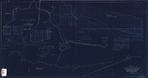
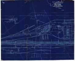
Blueprint showing proposed improvement of Las Vegas Springs, Las Vegas, Nevada, September 21, 1916
Date
Archival Collection
Description
'Exhibit A'. 'Approved Sept. 21, 1916.' '2-N-1719' handwritten in lower right corner. 'W.E.J."--Lower left corner. "L-44 - 50 to 61. T-75 - 17 & 46"--Upper left corner. Includes discharge figures and plans for improvements to springs. Scale [ca. 1:240]. 1 in. to 20 feet. -- Scale [ca. 1:2,400]. 1 in. to 200 ft. Vertical scale [ca. 1:48]. 1 in. to 4 feet. -- Scale [ca. 1:4,800]. 1 in. to 100 feet. 1 map. Contents: Detail at springs -- Profile -- Alignment.
Image
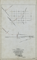
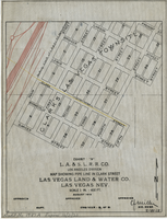
Map showing water pipeline in Arden, Nevada, May 4, 1913
Date
Archival Collection
Description
Image
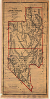
Map of Lincoln and Clark Counties, Nevada, 1908
Date
Description
Image
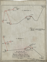
Sketch of plan and profile of present and proposed pipes and tanks and reservoirs at Sloan, Erie and Jean, Nevada, circa 1910s-1920s
Date
Archival Collection
Description
Image
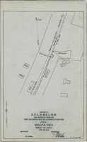
Map showing water connection for jail, Moapa, Nevada, December 28, 1914
Date
Archival Collection
Description
Image
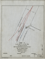
Map to accompany water contract, W. S. Cropper, Arden, Nevada, September 1919
Date
Archival Collection
Description
Image
Map showing water pipeline in Clark Street, Las Vegas, Nev., August 1919
Date
Archival Collection
Description
Image
Map showing water pipelines, Las Vegas, Nevada, January 15, 1914
Date
Archival Collection
Description
Image

Map of California, Nevada, Utah, Colorado, Arizona & New Mexico, circa 1867
Date
Description
Image