Search Results
Map of Las Vegas Valley Water District, April 16, 1953
Date
Archival Collection
Description
Image

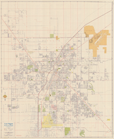
Street map of Las Vegas, North Las Vegas and vicinity, circa 1979
Date
Description
Image
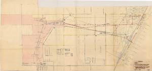
Map showing location of water-bearing lands to be sold to the Las Vegas Valley Water District, March 1, 1953
Date
Archival Collection
Description
Image
Map of Las Vegas, North Las Vegas, and vicinity, June 1975
Date
Description
Text
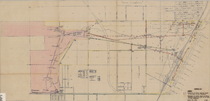
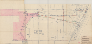
Maps showing sales of water production facilities of the Union Pacific Railroad Company and water distribution facilities of the Las Vegas Land and Water Co. to the Las Vegas Valley Water District, April 29, 1953
Date
Archival Collection
Description
Image
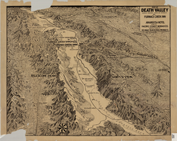
Map of Death Valley showing principal points of interest and Furnace Creek Inn, and Amargosa Hotel, circa 1930s
Date
Archival Collection
Description
Image
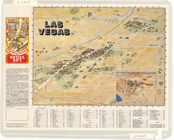
Map of the Las Vegas Strip, downtown Las Vegas and surrounding areas, 1987
Date
Description
Text
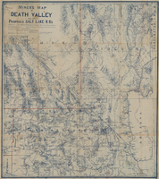
Miners map of Death Valley and the proposed Salt Lake railroads, January 1903
Date
Description
Subtitle: 'Including portions of San Bernardino and Inyo Counties, California; Nye and Lincoln Counties, Nevada and Mojave County, Arizona.' 'Compiled and drawn by A. Russell Crowell.' 'May 1902 (Corrected to Jan. 1903.' 'Property of H. Kehoe' written in ink in upper left corner. Scale [ca. 1:506,880]. 1 in. to 8 miles (W 118?--W 114?/N 38?--N 35?). Relief shown by hachures and spot heights. Blueline print. Library's copy has types of minerals found in different areas hand-printed in red and has red lines hand-drawn along county boundaries. G4351.H1 1903 .C76
Image

Topographic survey map of State Office Complex vicinity, September 25, 1970
Date
Description
Image
Street map of Las Vegas and North Las Vegas, circa 1963
Date
Description
Image