Search the Special Collections and Archives Portal
Search Results
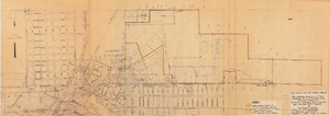
Map showing location of leased properties proposed to be sold to the Las Vegas Land and Water Company, October 2, 1952
Date
1952-10-02
Archival Collection
Description
'October 2, 1952.' Relief shown by contours. Hand-drawn lines mark land leased to these people, land proposed to be withdrawn from lease, and easement for a sewer. Scale [ca. 1:7,200]. 1 in.=600 feet. Blueline.
Image
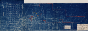
Map to accompany agreement with Willie T. Stewart, Vernon E. Bunker, Earl Leavitt and William Udell Stewart covering lease of Las Vegas Ranch property at Las Vegas, Nevada, January 31, 1951
Date
1951-01-31
Archival Collection
Description
'Las Vegas Land and Water Company, Exhibit A.' 'Office of Vice President, Los Angeles, Califormia. January 31, 1951.' Accompanies document: "N"L.D. 2454 (text of lease of the Las Vegas Ranch) (Box 11 Folder W18-1-12). Scale: 1" = 600'.
Image
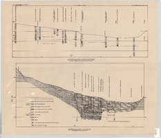
Cross-sections of wells and aquifers in the Las Vegas Valley, circa 1946
Date
1943 to 1949
Description
2 map sections on 1 sheet. Originally published as plate 6 in Geology and water resources of Las Vegas, Pahrump, and Indian Spring Valleys, Clark and Nye Counties, Nevada by George B. Maxey and C.H. Jameson, which is number 5 of the Water resources bulletin published by the Nevada Office of the State Engineer. Shows permeable and impermeable materials, wells, and aquifers.
Text
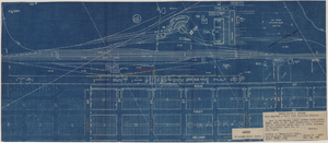
Map to accompany joint letter dated April 20th, 1931 to Mr. Gray concerning construction of proposed water main to serve lessees in Industrial Unit No. 1, Las Vegas, Nevada, April 20, 1931
Date
1931-04-20
Archival Collection
Description
'Union Pacific System. Los Angeles & Salt Lake Railraod Company.' 'Office of Industrial Engr., Los Angeles, California, April 20th, 1931. Dwg. No. 588.' Scale: 1" = 200'.
Image


Pagination
Refine my results
Content Type
Creator or Contributor
Subject
Archival Collection
Digital Project
Resource Type
Material Type
Place
Language

