Search Results
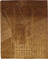
Map of major subdivisions near downtown Las Vegas, Nevada, circa 1931
Date
1928 to 1935
Archival Collection
Description
Map shows deed number and date of deed for some public properties and location and composition of water pipelines. '1-2-31' handwritten in upper right corner. Cadastral maps. Plat map with sepia tone..
Image
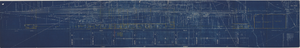
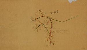
Map showing possible industrial users' connections to railroad pipelines in Las Vegas Nevada, circa 1930-1931
Date
1926 to 1936
Archival Collection
Description
Map showing industrial users' connections to railroad pipelines in Las Vegas, Nevada.
Image
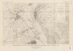
Map of part of Las Vegas Valley, Nevada, showing the approximate area of artesian flow, 1965
Date
1965
Description
At top of map: 'United States Department of the Interior, Geological Survey. Water supply paper 1780, plate 2.' At bottom of map: 'Base from U.S. Geological Survey Las Vegas (1952) and Henderson (1952) quadrangles.' 'Interior--Geological Survey, Washigton, D.C.--1965--W63358.' Relief shown by contours. Includes township and range lines. Thematic map. Scale 1:62,500 (W 115°15´--W 114°45´/N 36°15´--N 36°00´). Series: Water-supply paper (Washington, D.C.)
1780. Originally published as plate 2 of Available water supply of the Las Vegas ground-water basin, Nevada, by Glenn T. Malmberg, published by the Geological Survey in 1965 as its Water-supply paper 1780.
1780. Originally published as plate 2 of Available water supply of the Las Vegas ground-water basin, Nevada, by Glenn T. Malmberg, published by the Geological Survey in 1965 as its Water-supply paper 1780.
Image
Map of a portion of southern California and southwestern Nevada, circa early 1930s
Date
1930 to 1934
Description
Subtitle: 'Embracing the arid region of Mojave & Colorado deserts including Death Valley.' In lower right-hand corner: '1379.' In lower left-hand corner: 'Burke-Douglas.' Relief shown by shading and spot heights. On verso: Indexes to cities, towns, junctions, resorts, springs, wells, tanks, waterholes, lakes, reservoirs, rivers and creeks, mountains, valleys, mines, canyons, passes, grades, deserts, flats and ranches. Includes mileage tables. 'Prepared by the Route and Map Service of the Automobile Club of Southern California'--Panel. On verso: Map showing roads and points of interest in Death Valley & vicinity. Scale [ca. 1:823,680]. 1 in. to approx. 13 miles (W 119°--W 114°/N 38°--N 33°)
Text

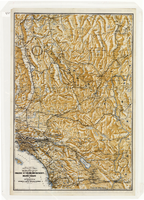
Map of the Las Vegas ground-water basin, Clark, Nye, and Lincoln Counties, Nevada, 1965
Date
1965
Description
At top of map: 'United States Department of the Interior, Geological Survey. Water-supply paper 1780, plate 1.' At bottom of map: 'Base from Army Map Service sheets NJ 11-9, NJ 11-12, and NI 11-3 (1947).' 'Boundary between bedrock and alluvium in Clark County, Nev., compiled by Ben Boyer, E. H. Pampeyan and C. R. Longwell. In Lincoln and Nye Counties, contact determined from aerial photographs.' 'Interior--Geological Survey, Washington, D.C.--1965--W63358.' Includes township and range lines.Relief shown by contours. Thematic map. Scale 1:250,000 (W 116°--W 114°45´/N 37°00´--N 35°30´). Series: Water-supply paper (Washington, D.C.), 1780. Originally published as plate 1 of Available water supply of the Las Vegas ground-water basin, Nevada, by Glenn T. Malmberg, published by the Geological Survey in 1965 as its Water-supply paper 1780.
Image
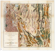
Geological reconnaissance map of Nevada south of the 40th parallel and adjacent California, 1903
Date
1903
Description
'Compiled from all available information by J.E. Spurr. Topographic base chiefly adapted from the maps of the Wheeler Survey.' 'U.S. Geological Survey, Bulletin No. 208, Pl. 1.' 'A. Hoen & Co. Lith. Baltimore, MD.' Relief shown by hachures and spot heights. Scale [ca. 1:950,000. 1 inch to approximately 15 miles] (W 120°--W 114°/N 40°--N 36°). Geological Survey bulletin, 208.
Image
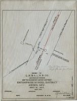
Map to accompany water contract, Enterprise School District, Arden, Nevada, September 1919
Date
1919
Archival Collection
Description
'Exhibit A. L.A. & S.L. R.R. Co., Los Angeles Division. Sept. 1919.' 'Approved [signed], C.F. Miller, Div. Engr.' 'I-W-67" hand-printed in lower right corner. 'Cancelled June 1st, 1920; Supts. file 129 - June 7th, 1920" handwritten on map. Scale: 1 in. : 100 ft.
Image
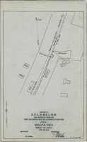
Map showing water connection for jail, Moapa, Nevada, December 28, 1914
Date
1914-12-28
Archival Collection
Description
'Exhibit A.' 'S.P.L.A.&.S.L.R.R., Los Angeles Division.' 'Approved, [signed] E.M. Jessup, E. M. of W.' 2-T-167A' hand-printed in lower right corner. Scale: 1 in. = 100 ft.
Image
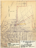
Map showing location of proposed well at Las Vegas, Nevada, August 24, 1948
Date
1948-08-24
Archival Collection
Description
'Office of Vice President, Los Angeles, California.' 'Dwg. F-225.' Relief shown by contours. Hand-drawn red line marks portion of ranch property owned by Land Company. Scale [ca. 1:7,200]. 1 in.=600 feet. Blueline.
Image
Map of the fifth level of the Clermont Mine, Goldfield, Nevada, circa 1902-1908
Date
1902 to 1908
Description
'Clermont, 5th level, el. 5098.2.' Hand-drawn, hand-colored and annotated map showing the fifth level of the Clermont Mine.
Image