Search Results
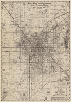
Map of Las Vegas Valley area, 1969
Date
1969
Description
'Featuring Las Vegas ... North Las Vegas ... Paradise Valley.' '1969 edition - revised' -- top of map. Original publisher: Front-Boy Service Co. 1969 ed. Scale [ca. 1:79,200]. 'Copyright - Russell A. Meador, 1968.' Front panel title: 'Front Boy's official 1969 edition street map.' Indexes on map verso. 'Walt Choik, editor, Front Boy Maps' -- back panel.
Text
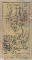
Map of a part of southern Nevada showing ground-water conditions, 1914
Date
1914
Description
At bottom of map: 'Base compiled from plane-table sheets, topographic maps of U.S. Geological Survey, railroad alignments, and General Land Office data.' Relief shown by hachures and spot heights. Shows township and range grid. Covers from southeast corner of White Pine County to Sloan and from Nye County border to Arizona-Utah border. Shows flowing wells, nonflowing wells, springs, flowing-well areas, dry holes and shore lines of ancient lakes. Scale 1:500,000 (W116°--W 114°/N 45°--N 36°). Series: Water-supply paper (Washington, D.C.), 365. Map is plate 1 from the U.S. Geological Survey water-supply paper 365.
Image
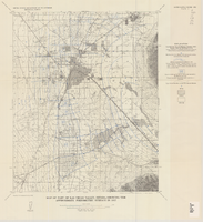
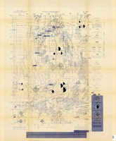
Map of part of Las Vegas Valley, Nevada, showing the approximate piezometric surface in 1912
Date
1965
Description
'Base by U.S. Geological Survey, 1952.' 'Interior--Geological Survey, Washington, D.C.--1965--W63358.' 'Compiled from data published by Carpenter (1915), Kearney (1913), and McWilliams (1913).' Relief shown by contours. Includes township and range lines. Scale 1:62,500 (W 115°15´--W 115°00´/N 36°15´--N 36°00´). Series: Water-supply paper (Washington, D.C.)
1780. Originally published as plate 7 of Available water supply of the Las Vegas ground-water basin, Nevada, by Glenn T. Malmberg, published by the Geological Survey in 1965 as its Water-supply paper 1780.
1780. Originally published as plate 7 of Available water supply of the Las Vegas ground-water basin, Nevada, by Glenn T. Malmberg, published by the Geological Survey in 1965 as its Water-supply paper 1780.
Image
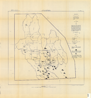
Map showing chemical diagrams representing quality of water in Clark and Nye counties, Nevada, 1963
Date
1963
Description
'T.E. Eakin, S.L. Schoff, and P. Cohen, 1963.' 'Department of the Interior, United States Geological Survey, TEI-833.' 'Prepared in cooperation with the U.S. Atomic Energy Commission.' Scale 1:500,000 (W 117°00´--W 115°00´/N 38°30´--N 36°30´). Originally published as figure 3 in Regional hydrology of a part of southern Nevada : a reconnaissance / by Thomas E. Eakin, Stuart L. Schoff, and Philip Cohen, published by the U.S. Geological Survey in 1963 as number 833 of the Trace elements investigation report.
Image

Redevelopment plan map for downtown Las Vegas, Nevada, November 18, 1987
Date
1987-11-18
Description
Scale [ca. 1:12,000. 1 inch equals approx. 1,000 feet]. 1 map ; on sheet 61 x 46 cm. "Nov. 18, 1987." "All land use designations on this map are to be interpreted in conformance with the community profiles component of the Las Vegas General Plan." City of Las Vegas?.
Image
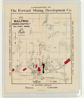
Map of the Bullfrog Mining District, Nye County, Nevada, circa 1905
Date
1901 to 1909
Description
At top of map: 'Compliments of the Forward Mining Development Co.' On left and right margins: 'The Patrick Investment Company, Fiscal Agents.' At bottom of map: '19 Toltec Block, Denver, Colorado.' 'The Williamson-Haffner Co., Denver.' Relief shown by hachures. Properties owned by Patrick Investment Company are marked in red. Shows railroads, roads, and pipelines. Scale [ca. 1:39,000. 1 in. to approx. 3,250 feet].
Image
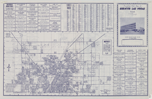
Street map of greater Las Vegas, Nevada, circa 1965-1968
Date
1965 to 1968
Description
37 x 64 cm. on sheet 57 x 89 cm., folded to 29 x 23 cm. On verso: continuation of map. Includes index and advertisements. Original publisher: Western States Publishing Co..
Image
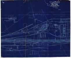
Map showing water pipelines, Las Vegas, Nevada, January 15, 1914
Date
1914-01-15
Archival Collection
Description
'S.P.L.A.&S.L.R.R., Los Angeles Division.' 'Jan. 15, 1914.' Includes other parts of water utilities besides pipelines such as sump pumps and water tanks. Scale varies. Blueprint. Library's copy includes hand-written notes.
Image
Map of the Nevada Test Site and vicinity showing principal rock types and chemistry of ground water, 1964
Date
1964
Description
'Compiled by S.L. Schoff and J.E. Moore.' 'Geology generalized from geologic maps of the Nevada Test Site by Special Projects Branch, U.S. Geological Survey; of Lincoln County by Tschanz and Pampeyan (1961); and of Clark County by Bowyer, Pampeyan, and Longwell (1958).' United States Department of the Interior, Geological Survey. Prepared in cooperation with the U.S. Atomic Energy Commission.' 'TEI-838.' Scale 1:125,000 (W 116°00´--W 116°15´/N 37°15´--N 36°30´). Originally published as figure 1 in Chemistry and movement of ground water, Nevada Test Site / by Stuart L. Schoff and John E. Moore, published by the Geological Survey in 1964 as number 838 of the Trace elements investigations report.
Image
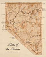
Map showing eighteenth- and nineteenth-century pioneer routes through the state of Nevada
Date
1941 to 1951
Description
Compliments of Harolds Club, Reno. Published between between 1941 and 1951? Scale [ca 1:1,250,000].
Image