Search Results

Topographic map of the Las Vegas Valley area, 1959
Date
1959
Description
Scale 1:250,000 ; Transverse Mercator proj. (W 116°--W 114°/N 37°--N 36°) ; 1 map : col. ; 45 x 72 cm ; Relief shown by contours and spot heights. Contour interval 200 feet ; Margin title ; "Compiled in 1955 by photogrammetric methods by U.S. Coast and Geodetic Survey and from Nevada 1:48,000 and 1:62,500, USGS, 1952-54, and Nevada 1:50,000, CE, 1952. Planimetric detail revised by photo-planimetric methods. Horizontal and vertical control by USGS, USC& GS, and CE. Photography field annotated 1954. Road data 1954." ; Shows townships and ranges ; Gives 1955 declination from true north ; Includes location diagram, reliability diagram, and sectionalized township map ; Filing title: Las Vegas, Nevada; Arizona; California ; Interior--Geological Survey
Image
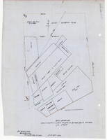
Plat showing cultivated land in the Stewart Ranch, Las Vegas, Nevada, December 8, 1902
Date
1902-12-08
Archival Collection
Description
'John T. McWilliams, U.S.M. Surveyor, Goodsprings, Nevada.' 'Dec. 8th 1902.' '60-A-Pt.II' handwritten in upper right corner. This is map of the Stewart Ranch, which was originally the Las Vegas Ranch, site of the Old Mormon Fort. Drawn with ink and colored pencil. Two holes punched on right side..
Image
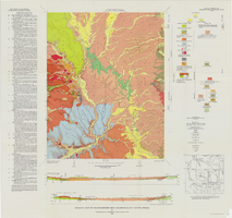
Geologic map of the Buckboard Mesa quadrangle, Nye County, Nevada, 1966
Date
1966
Description
58 x 46 cm., on sheet 87 x 91 cm., folded in envelope 30 x 24 cm. Relief shown by contours and spot heights. "Contour interval 20 feet." "Prepared in cooperation with the U.S. Atomic Energy Commission." "Geology mapped in 1962-63." Includes text, 2 col. cross sections, and 2 index maps. Original publisher: U.S. Geological Survey, Series: Geologic quadrangle map GQ, Scale: 1:24 000.
Image

Cross-section maps of Combination and Florence Mines, Goldfield, Nevada, circa 1902-1908
Date
1902 to 1908
Description
Maps of Combination and Florence Mines, Goldfield, Nevada.
Image
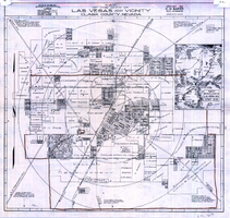
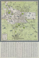
Map of the city of Las Vegas and vicinity, Clark County, Nevada, 1929
Date
1929
Description
'Copyright 1929, C.D. Baker, civil engineer. Drawn by R.C. Kenmir.' Includes inset sketch showing general location of Las Vegas, Nev. Relief shown pictorially on inset map. Scale [ca. 1:39,600. 1 in. to 0.625 mile]. Cadastral map. Library's copy 1 has hand-drawn brown line and red circles. Library's copy 2 has "Proposed annexation" printed in capital letters in red pencil near the top, has a brown line drawn around the area.
Image
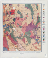
Geologic reconnaissance map of portions of southwestern Nevada and eastern California, 1905
Date
1905
Description
At top of map: 'U.S. Geological Survey, Charles D. Walcott, director.' At bottom of map: 'E.M. Douglas, Geographer. R.H. Chapman, in charge of section.Triangulation and topography by R.H. Chapman and B.D. Stewart. Surveyed in 1905.' 'Geology by Sydney H. Ball. Geology in immediate vicinity of Goldfield and Bullfrog generalized from maps by F.L. Ransome assisted by George H. Garrey and W.H. Emmons.' Scale 1:250,000 (W 117°30--W 116°/N 38°--N 36°)
Image
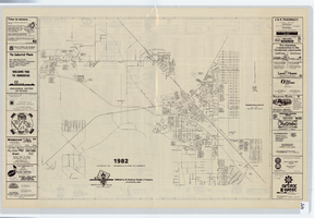
Map of Las Vegas and vicinity, 1963
Date
1963
Description
42 x 39 cm., folded to 21 x 9 cm. Panel title: Las Vegas and southern Nevada map and street guide. Includes index. Includes illustrations . Advertisement for Nevada State Bank, text with facts about Las Vegas and maps of Henderson, Boulder City and downtown Las Vegas on verso. "Courtesy of Nevada State Bank."--Panel. Original publisher: Thomas Bros. Maps.
Image
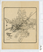
Map of Tonopah Mining District, Nye County, Nevada, circa 1903
Date
1899 to 1907
Description
Map showing mining claims in Tonopah Mining District, including areas owned by Tonopah Amalgamated Mining Co.; David Keith's Company of Salt Lake, Utah; Mispah Extension Company; Tonopah Mining Company of Nevada; Gold Hill Mining Co. Relief shown by hachures. Scale [ca. 1:7,200]. 1 in. equals 600 feet. Library's copy has some mines cross-hatched in pencil.
Image
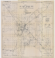
Map of Las Vegas artesian basin, Clark County, Nevada, April 1946 (Water Resources Bulletin no. 4, plate 1)
Date
1946-04
Description
'April, 1946.' 'Showing location of wells, springs, and boundary between valley fill and bedrock.' Originally published as plate 1 in number 4 of the Water resources bulletin published by the Nevada Office of the State Engineer. Scale [ca. 1:63,360. 1 in. to approx. 1 mile] (W 115°10?--N 115°/N 36°20?--N 36°). G4354.L3C34 1946 .N482
Image