Search Results
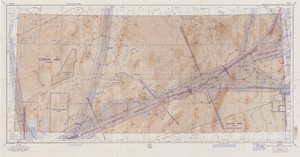
Elko sectional aeronautical chart, September 29, 1959
Date
Description
Image

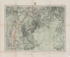
Map showing detailed topography of the country traversed by the reconnaissance expedition through southern & southeastern Nevada, 1869
Date
Description
no. 1.miles. Library's copy has counties hand-outlined in colored markers.
Image

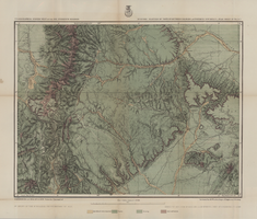
Map showing detailed topography of the country traversed by the reconnaissance expedition through southern & southeastern Nevada, 1869 (reproduction)
Date
Description
no. 1. Reproduction. Map is printed in purple. Scale of original map: [1:760,320]. 1 in. to approx. 12 miles. Includes dots hand-colored with red pencil marking Indian rancherias.
Image

Map of economical features of parts of southern Colorado and northern New Mexico, January 8, 1878
Date
Description
37 x 49 cm. Relief shown by hachures and spot heights. "Atlas sheet no. 69(B)." "Issued Jan'y 8th 1878." "Expeditions of 1874-1875 & 1877 under the command of 1st. Lieut. Geo. M. Wheeler, Corps of Engineers, U.S. Army." Prime meridians: Greenwich and Washington, D.C. "Weyss, Lang & Herman, del." "By order of the honorable the Secretary of War." "Under the direction of Brig. General A. A. Hunphreys, Chief of Engineers, U. S. Army." Original publisher: U.S. Geographical Surveys West of the 100th Meridian, Scale: 1 inch to 4 miles or 1: 253440.
Image
Map of economic features, part of central New Mexico, May 7, 1877
Date
Description
37 x 50 cm. Relief shown by hachures and spot heights "Atlas sheet no. 77(B)." "Issued May 7th 1877." "Expeditions of 1871 & 1786 under the command of 1st. Lieut. Geo. M. Wheeler, Corps of Engineers, U.S. Army." "Weyss, Herman & Lang, del." "By order of the honorable the Secretary of War." "Under the direction of Brig. General A. A. Hunphreys, Chief of Engineers, U. S. Army." "2nd. Ed. June 30th, 1881." Original publisher: U.S. Geographical Surveys West of the 100th Meridian, Scale: 1 inch to 4 miles or 1: 253440.
Image
Map of economic features of parts of southern Colorado and northern New Mexico Atlas sheet no. 70(A.), May 5, 1877
Date
Description
Image