Search Results
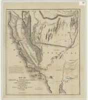
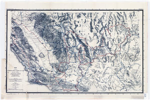
Map of Oregon and upper California from the surveys of John Charles Frémont and other authorities, 1848
Date
Description
Image
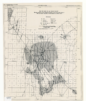
Map of part of Las Vegas Valley showing contours of the composite piezometric surface during the spring of 1944, and specific capacities of wells tapping the confined water
Date
Description
Relief shown by contours. Includes range and township grid. Shows springs and wells. Scale [ca. 1:67,162. 1 in. to approx. 1.06 miles]. Series: Water resources bulletin (Carson City, Nev.)
no. 5. Originally published as plate 8 in Geology and water resources of Las Vegas, Pahrump, and Indian Spring Valleys, Clark and Nye Counties, Nevada by George B. Maxey and C.H. Jameson, which is number 5 of the Water resources bulletin published by the Nevada Office of the State Engineer.
Image
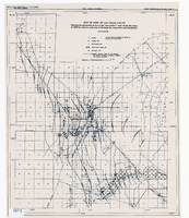
Map of part of Las Vegas Valley showing the piezometric surface of the "near-surface" water during the spring of 1946 by contours, and areas of discharge by evaporation and transpiration
Date
Description
Relief shown by contours. Includes range and township grid. Shows springs, wells and areas of discharge. Scale [ca. 1:67,162. 1 in. to approx. 1.06 miles]. Series: Water resources bulletin (Carson City, Nev.)
no. 5. Originally published as plate 7 in Geology and water resources of Las Vegas, Pahrump, and Indian Spring Valleys, Clark and Nye Counties, Nevada by George B. Maxey and C.H. Jameson, which is number 5 of the Water resources bulletin published by the Nevada Office of the State Engineer.
Image
Map of parts of California, Nevada, Arizona and Utah : traversed in 1891 by the Death Valley Expedition (a biological survey conducted by the U.S. Dept. of Agriculture), C. Hart Merriam in charge
Date
Description
Image
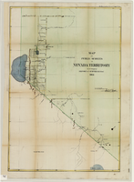
Map of public surveys in Nevada Territory to accompany report of Surveyor General, October 1, 1862
Date
Description
Image
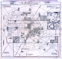
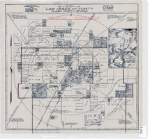
Map of the city of Las Vegas and vicinity, Clark County, Nevada, 1929
Date
Description
Image
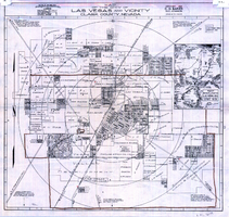
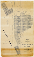
Map of the city of Las Vegas, Nevada, March 1, 1927
Date
Description
Image