Search Results
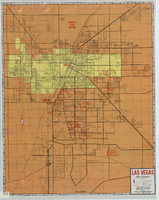
Street map of Las Vegas and vicinity, 1965
Date
1905-05-18
Description
1965 [ed.]. Color; 70 x 55 cm., folded to 24 x 10 cm. Panel title: Las Vegas, North Las Vegas and vicinity street map, home buyers guide. "1/65." Includes names of subdivisions. Index and advertisements for subdivisions on verso. "Compliments of First Western Savings & Loan Association."--Panel. "Drawn by Bob and Beverly Bennett, 1/65." Original publisher: Amusement Guide Publications of America.
Image

Topographic survey map of State Office Complex vicinity, September 25, 1970
Date
1970-09-25
Description
Blueline map, 74 x 110 cm. "Portion SE? SW? Section 27, Township 20 south, Range 61 east, M.D.M. & M., City of Las Vegas, Nev." "This survey was completed on September 25, 1970, at the instance of the state of Nevada Planning Board and correctly shows the elevation of all buildings and other structures." Shows City of Las Vegas Library, Dula Center, Nevada Highway Patrol building, YMCA. and State of Nevada Office Building. Library's copy is missing the lower right corner. Stamped in lower right-hand corner "Stephen F. Turner, Registered land surveyor - State of Nevada, No. 1803."
Image
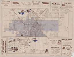
Map of the city of Las Vegas, North Las Vegas, the "Strip", 1957
Date
1957
Description
35 x 50 cm., folded to 22 x 10 cm. Panel title: Inside the greater Las Vegas area. Copyright held by Robert E. Barringer. Map is irregularly shaped. Map of California from San Francisco to Los Angeles to Las Vegas by Beth Bergh, index and advertisements on verso. Includes advertisements for Las Vegas businesses. Stamped on panel of Library's copy: Harrington Insurance Agency. Original publisher: Redwood Publishing Co..
Image
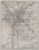
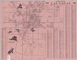
Map of greater Las Vegas, 1960
Date
1960
Description
55 x 44 cm., folded to 30 x 12 cm. Relief shown by spot heights. Includes notes and quotations. Includes indexes. Panel title: Front Boy's official 1962-1963 edition street map: detailed guide of North Las Vegas, Las Vegas, Paradise Valley and vicinity. 1962-1963 ed. Original publisher: Front Boy Service Co..
Image

Street map of the city of Las Vegas & vicinity, showing streets, main roads and recreation areas, 1954
Date
1954
Description
7 maps on 3 sheets, 2 leaves ; 21 x 31 cm. or smaller on sheets 22 x 35 cm. folded to 22 x 13 cm. in paper cover. Title from cover. Copyright held by James E. Stringer. 1st ed. Includes maps of North Las Vegas, the Strip and Vegas Heights and Meadow Acres. Includes key to map coordinates. Includes index. "Map of Las Vegas & Vicinity showing streets, main roads, and recreation areas." Original publisher: R.W. Baldwin.
Image
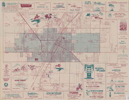
Map of the city of Las Vegas, North Las Vegas, the "Strip", 1957
Date
1957
Description
35 x 50 cm., folded to 22 x 10 cm. 1958 edition. Copyright held by Robert E. Barringer. Panel title: Welcome map, greater Las Vegas area and scenic routes to and from there. "The Raele McCoy Co." Map is irregularly shaped. Index on verso. Includes advertisements for Las Vegas businesses and notes. Birdseye-view map The Las Vegas area : wonderland of the West : on the Old Spanish Trail; advertisements and helpful information on Las Vegas on verso. "1958 edition." Original publisher: Redwood Publishing Co..
Image
Greater Las Vegas, 1957
Date
1957
Description
42 x 44 cm., folded to 22 x 14 cm. Title in upper-right margin: Greater Las Vegas. Copyright held by Robert E. Barringer. Includes index. Map is irregularly shaped. Original publisher: Redwood Publishing Co..
Image
A general map of Las Vegas, 1969
Date
1905-05-22
Description
Color; 60 x 55 cm. on sheet 64 x 96 cm. At top left of map: Map of greater Las Vegas. Includes index.
Image

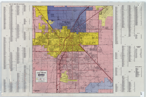
Map of the city of Las Vegas, North Las Vegas, "the Strip," 1960
Date
1960
Description
1960 edition. 41 x 43 cm. Copyright held by Robert E. Barringer. Title in upper-right corner of map: Las Vegas area map. Irregularly-shaped map. Includes index, notes, list of Las Vegas schools and inset maps of East Las Vegas (Whitney) and Wherry housing area on Nellis Air Force Base. Original publisher: Redwood Publishing Co..
Image

Map of the city of Las Vegas, North Las Vegas, the "Strip", 1963
Date
1963
Description
39 x 36 cm., folded to 28 x 15 cm. Panel title: Welcome map, greater Las Vegas area and scenic routes to and from there. Copyright held by Robert E. Barringer. Includes advertisements for Las Vegas businesses, inset of map of Henderson, Nev., and index. Map of California from San Francisco to Los Angeles to Las Vegas by Beth Bergh, advertisements and index on verso Christmas ed. Greater Las Vegas, 1963-1964 ed. Original publisher: Redwood Publishing Co..
Image