Search Results
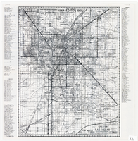
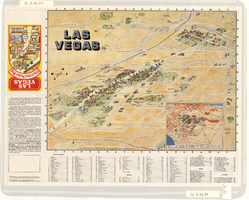
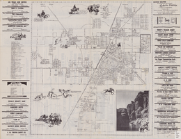
Map of greater Las Vegas area, 1964-1965
Date
1964 to 1965
Description
Scale [ca. 1:51,322] ; 1 map ; 55 x 43 cm ; Panel title: Front Boy's official 1964-1965 edition street map : detailed guide of North Las Vegas, Las Vegas, Paradise Valley and vicinity ; Originally folded to: 29 x 12 cm ; Relief shown by spot heights ; Includes notes and quotations ; Includes indexes; Alt Title: Front Boy's official 1964-1965 edition street map : detailed guide of North Las Vegas, Las Vegas, Paradise Valley and vicinity ; Alt Title: Official 1964-1965 edition street map Front Boy Service Co..
Text
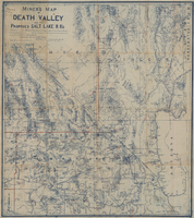
Miners map of Death Valley and the proposed Salt Lake railroads, January 1903
Date
1903-01
Description
Subtitle: 'Including portions of San Bernardino and Inyo Counties, California; Nye and Lincoln Counties, Nevada and Mojave County, Arizona.' 'Compiled and drawn by A. Russell Crowell.' 'May 1902 (Corrected to Jan. 1903.' 'Property of H. Kehoe' written in ink in upper left corner. Scale [ca. 1:506,880]. 1 in. to 8 miles (W 118?--W 114?/N 38?--N 35?). Relief shown by hachures and spot heights. Blueline print. Library's copy has types of minerals found in different areas hand-printed in red and has red lines hand-drawn along county boundaries. G4351.H1 1903 .C76
Image

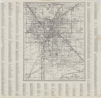
Greater Las Vegas, 1960
Date
1960
Description
87 x 68 cm. Relief shown by spot heights. Includes notes and quotations. Includes indexes. "1961 edition." Original publisher: Front.
Image
Greater Las Vegas, 1963
Date
1963
Description
1864-1964 (centennial) editon. 72 x 57 cm. Relief shown by spot heights. Includes notes and quotations. Includes indexes. Original publisher: Front.
Image
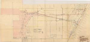
Map showing location of water-bearing lands to be sold to the Las Vegas Valley Water District, March 1, 1953
Date
1953
Archival Collection
Description
'Exhibit A.' 'March 1, 1953.' 'I-128.' Shows location of water-bearing lands to be sold to the Las Vegas Valley Water District and the boundary of lands owned by Union Pacific which are not to be sold to the district. The Union Pacific Railroad Company owned the Las Vegas Land and Water Company. Also shows pipes, proposed pipes, other parts of the water system, power lines, and lists power requirements for water system. Includes township and range lines. Las Vegas Land and Water Company
Image
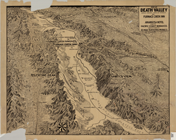
Map of Death Valley showing principal points of interest and Furnace Creek Inn, and Amargosa Hotel, circa 1930s
Date
1930 to 1939
Archival Collection
Description
Relief shown by landform drawings and spot heights. Oblique perspective map. Library's copy is missing lower left corner and piece in upper margin near left corner
Image
Maps showing sales of water production facilities of the Union Pacific Railroad Company and water distribution facilities of the Las Vegas Land and Water Co. to the Las Vegas Valley Water District, April 29, 1953
Date
1953
Archival Collection
Description
Union Pacific Railroad Co.
Image
Map of the Las Vegas Strip, downtown Las Vegas and surrounding areas, 1987
Date
1987
Description
Panel title: Las Vegas illustrated pocket map. Bird's-eye view map of the Strip and downtown Las Vegas. Shows casinos, motels, golf courses, recreational vehicle parks, and other places of interest to tourists. Includes indexes. Includes text and inset map of locations of other cities and sites of interest to tourists in the surrounding states and their distances from Las Vegas. Travel Graphics International (Firm)
Text
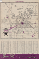
Street map of Las Vegas and North Las Vegas, circa 1963
Date
1961 to 1965
Description
36 x 37 cm. Panel title: Las Vegas area map. Includes index. Advertisements for Round-up Real Estate on verso. Original publisher: Round.
Image
Street map of the city of Las Vegas, North Las Vegas, the "Strip", 1955
Date
1955
Description
41 x 38 cm., folded to 28 x 15 cm. Panel title: Welcome map, greater Las Vegas area. Includes inset map of Meikle Manor subdivision. Includes list of churches in Las Vegas, mileages from Las Vegas to other cities in the Southwest and notes. Helldorado ed. 1955. Map is irregularly shaped. Index and advertisements on verso. Original publisher: Adco Publishing Co..
Image