Search Results
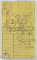
Street map of Las Vegas, North Las Vegas and vicinity, circa 1969
Date
1905-05-22
Description
Color; 100 x 58 cm., folded to 24 x 11 cm. "569." Indexes on verso. Library's copy has a small piece missing along the left-hand side of the map. Original publisher: California State Automobile Association.
Image

Map of California and Territories of New Mexico and Utah, 1862
Date
1862
Description
Scale [ca. 1:3,231,360. 1 in. to approx. 51 miles] (W 125°00--W 103°30/N 42°00--N 31°45) ; 1 map : hand col. ; 40 x 60 cm., on sheet 46 x 68 cm ; Relief indicated by hachures and spot heights ; Prime meridians: Greenwich and Washington, D.C ; Decorative border ; Hand colored ; Atlas p. numbers in upper margin: 58-59 ; Date est. from territorial borders and county configuration ; Shows natural features, locations of Indian tribes, proposed railroad routes, routes of explorers, trails, county boundaries and populated places ; Johnson and Ward
Image
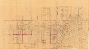
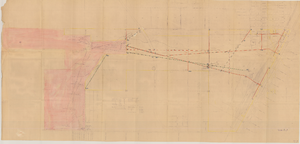
Map of Las Vegas showing areas owned by the Union Pacific Railroad Company, water pipes and other water utilities, circa 1942
Date
1938 to 1946
Archival Collection
Description
Map showing downtown Las Vegas and tracts to the west showing water supply lines, wells, springs, and settling basins. Various areas outlined in red and yellow. Scale [ca. 1:7,200] 1 in.=600 feet. Cadastral map. Blueline print. Areas owned by railroad outlined by hand in different colored markers. Library's copy includes hand-written calculations.
Image
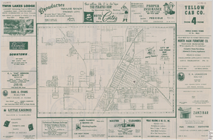
Street map of the city of Las Vegas, 1954
Date
1954
Description
22 x 34 cm. on sheet 36 x 54 cm. Copyright held by Redwood Publishing Co. Includes advertisements. 1954 [ed.] Street index, map of the Strip and advertisements on verso. Map is irregularly shaped. Original publisher: Redwood Pub. Co..
Image

Map of California and territories of New Mexico and Utah, circa 1861
Date
1859 to 1862
Description
'Compiled, drawn, and engraved under the supervision of J.H. Colton and A.J. Johnson.' Relief shown by hachures and spot heights. Scale [ca. 1:3,041,280]. 1 in. to approx. 48 miles (W 124°--W 103°/N 42°--N 31°). Hand coloredPrime meridians: Greenwich and WashingtonPlates 54 & 55 removed from Johnson's New illustrated family atlas of the world, with descriptions geographical, statistical and historical ... New York, 1862Title page of atlas.
Image
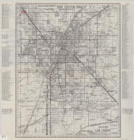
Map of greater Las Vegas area, 1964-1965
Date
1964 to 1965
Description
Scale [ca. 1:51,322] ; 1 map ; 55 x 43 cm ; Panel title: Front Boy's official 1964-1965 edition street map : detailed guide of North Las Vegas, Las Vegas, Paradise Valley and vicinity ; Originally folded to: 29 x 12 cm ; Relief shown by spot heights ; Includes notes and quotations ; Includes indexes; Alt Title: Front Boy's official 1964-1965 edition street map : detailed guide of North Las Vegas, Las Vegas, Paradise Valley and vicinity ; Alt Title: Official 1964-1965 edition street map Front Boy Service Co..
Text
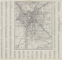
Street map of greater Las Vegas, 1963
Date
1963
Description
55 x 44 cm. Panel title: Front Boy's official 1963-1964 edition street map : detailed guide of North Las Vegas, Las Vegas, Paradise Valley and vicinity. Relief shown by spot heights. Originally folded to: 29 x 12 cm. "Note, revised and recorded 1st - 1961, 2nd - 1962, 3rd 1963, 4th - 1963."On verso: "MAR 1964" stamped in red ink on upper right hand corner. Includes notes and quotations. Includes indexes. Original publisher: Front.
Image

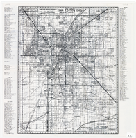
Greater Las Vegas, 1960
Date
1960
Description
87 x 68 cm. Relief shown by spot heights. Includes notes and quotations. Includes indexes. "1961 edition." Original publisher: Front.
Image
Greater Las Vegas, 1963
Date
1963
Description
1864-1964 (centennial) editon. 72 x 57 cm. Relief shown by spot heights. Includes notes and quotations. Includes indexes. Original publisher: Front.
Image
Map of Las Vegas Valley Water District, December 29, 1952
Date
1952-12-29
Archival Collection
Description
'Exhibit A.' 'Dec. 29, 1952.' 'I-128.' Scale [ca. 1:3,600]. 1 in.=300 feet. Shows water pipelines, other parts of the water system, and power lines to be removed or relocated when land is sold to the Las Vegas Valley Water District. Shows land to be sold and lists power requirements for water system. Includes township and range lines. Library's copy includes hand-written notations and calculations. Los Angeles & Salt Lake Railroad Company, Office of Vice President?
Image