Search Results

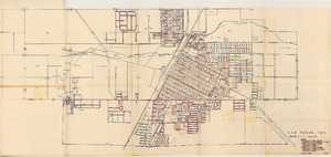
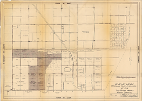
Map of the Las Vegas Strip, May 1950
Date
1950-05
Description
Scale [ca. 1:10,200. 1 in. to approx. 850 ft.] ; 1 map : col. ; 54 x 28 cm ; Cadastral map ; "May 1950." Campbell Realty.
Image
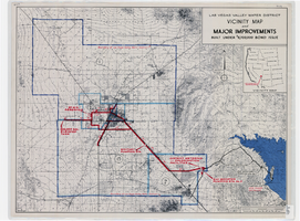
Map showing improvements made to the Las Vegas Valley Water District and vicinity under $8,700,000 bond issue,circa 1957
Date
1953 to 1961
Description
Relief shown by contour lines and spot heights. Includes inset location map of the Water District. Shows township and range grid. Boundary of Las Vegas Valley Water District marked in dark blue. 'Cole '57' in lower left corner. Scale [ca. 1:72,000. 1 in. to approx. 6,000 ft.]
Image
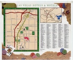
Map of Las Vegas hotels & motels, June 1990
Date
1990-06
Description
Color; 33 x 27 cm. on sheet 46 x 55 cm., folded to 23 x 10 cm. Panel title: Las Vegas area map. Shows locations of hotel and motels in the area of the Strip and Downtown. Also shows locations of country clubs. Includes a separate map of locations of hotels and motels in the surrounding area including North Las Vegas. Includes index. "LVM-75M-6/90."--Verso. Map of locations of golf courses on the verso along with information on points of interest, attractions, general information, tennis, bowling, recreational vehicle parks, and golf.
Image
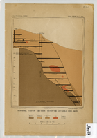
Vertical cross-section of Eureka Consolidated Mine, 1883
Date
1883
Description
'G. F. Becker, geologist-in-charge. Julius Bien & Co. lith. Mapping and geology by J. S. Curtis.' 'U.S. Geological Survey. Annual report 1883, pl. XXXIII.' Published by U.S. Geological Survey. Scale [ca. 1:2,400] 1 in.=200 feet. Library's copy has "Nev." printed in pencil in upper right corner.
Image
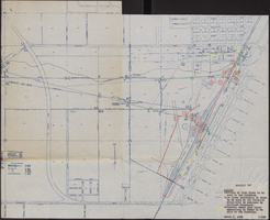
Map showing various facilities of the Las Vegas Land and Water Company, March 1, 1953
Date
1953-03-01
Archival Collection
Description
'Exhibit C.' 'March 1, 1953.' 'I-67.' Scale [ca. 1:7,200] 1 in.=600 feet. Map shows facilities [mainly water-pipes] of Las Vegas Land and Water Company completed and those under construction as of September 1, 1952, and facilities which were commenced after September 1, 1952, and prior to March 1, 1953. Map made as part of the papers for the sale of Las Vegas Land and Water Company facilities to the Las Vegas Valley Water District. Shows township and range lines. Library's copy has hand-written notes in pencil. Las Vegas Land and Water Company?
Image
Plan of lands proposed to be purchased by the Las Vegas Valley Water District, August 1, 1952
Date
1952-08-01
Archival Collection
Description
'Date: August 1, 1952. Approved, Thomas A. Campbell, Pres.' Scale: [1 in.=approx. 300 feet]. Library's copy 2 has additional areas shaded, with original shaded areas outlined in red, plus various handwritten notations in pencil.
Image
Map of water pipelines owned by or to be sold to the Las Vegas Valley Water District, March 1, 1953
Date
1953-03-01
Archival Collection
Description
Map shows portions of pipelines to be sold to the Las Vegas Valley Water District, pipelines connected to those to be sold to the District that will be retained by the railroad companies, and privately-owned pipelines connecting to those to be sold to the District. 'Exhibit D.' 'March 1, 1953.' 'I-128.' Las Vegas Land and Water Company?
Image
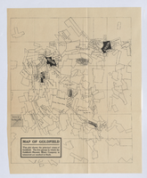
Map of Goldfield, circa 1904-1908
Date
1900 to 1912
Description
'This plat shows the principal mines of Goldfield. The five groups in which the Goldfield-Majestic Mines Company is interested are marked in black.'
Image
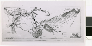
Map of irrigable areas near Boulder Dam, February 20, 1935
Date
1935-02-20
Archival Collection
Description
'Drawn by C.G.C.' 'Carson City, Nevada, Feb. 20, 1935. No. 4.' 'Adapted from Bureau of Reclamation's General map of irrigable areas.'
Image
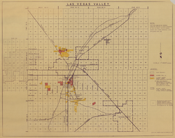
Map of Las Vegas Valley, 1968
Date
1968
Description
'This map compiled by General Drafting Service to show purchases in the Las Vegas area by Howard Hughes and others reported to be affiliated with him.' Shows land owned by Howard Hughes and land owned by Hughes Tool Company. Includes locations of casinos on Las Vegas Strip. Original publisher: General Drafting Service. Scale [ca. 1:48,000]. 1 in. to 4,000 feet. Hand-colored.
Image