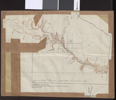
Search Results

Map of Las Vegas Valley showing artesian wells, circa 1920
Date
1918 to 1922
Description
Scale not given ; 1 map ; 66 x 55 cm ; Blueline print ; Cadastral map ; Includes township and range grid ; Includes quotations McWilliams?
Image
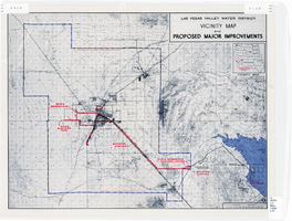
Map showing improvements made to the Las Vegas Valley Water District and vicinity, circa 1950
Date
1946 to 1954
Description
Relief shown by contour lines. Includes inset map showing the location of the Las Vegas Valley Water District Project. In lower left corner: 'Cole...O.' Boundary of Las Vegas Valley Water District marked in dark blue. Scale [ca. 1:126,720. 1 in. to approx. 2 miles
Image
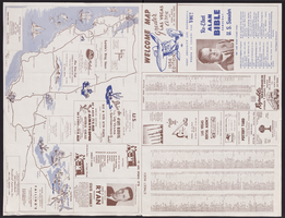
Map of Las Vegas, North Las Vegas, and The Strip, 1956
Date
1956
Description
1956 ed. 'Compiled by Redwood Publishing Co. Copyright 1956 by Robert E. Barringer ... Las Vegas, Nevada.' Panel title: Welcome map, greater Las Vegas area and scenic routes to and from there. Map of California from San Francisco to Los Angeles to Las Vegas drawn by Beth Bergh. Includes notes and street index. Includes advertisements for Las Vegas and California businesses. Scale [ca. 1:35,640. 1 in. to approx. 0.56 mile].
Text
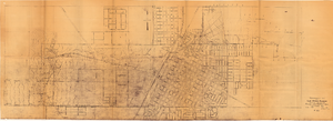
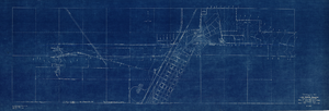
Topographic map of Las Vegas Rancho, showing location of wells and water lines, Las Vegas, Nev., October 18, 1946
Date
1946-10-18
Archival Collection
Description
'May 1, 1940. Revised Oct. 18, 1946.' 'F-225.' Relief shown by contours. Scale [ca. 1:7,200] 1 in.=600 feet.
Image
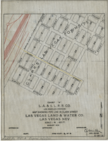
Map showing water pipeline in Clark Street, Las Vegas, Nev., August 1919
Date
1919-08
Archival Collection
Description
'Exhibit A. L.A & S.L. R.R. Co., Los Angeles Division.' ' Las Vegas Land & Water Co., Las Vegas, Nev.' 'August 1919' (?) 'Approved [signed] C.F. Miller Div. Engr. '2-W-18.' Handwritten in lower left margin: 'Audit No.1987A. Expires 12/31/23.' Pipeline marked in yellow. Area of Las Vegas in map labeled as 'Clark's Las Vegas Townsite.' Scale: 1 in. = 400 ft.
Image
Topographic map of Arrow Canyon dam and reservoir site on the Muddy River, 1934
Date
1934
Archival Collection
Description
'Topography by Lee Morrison. Control by U.S. Geological Survey and U.S. Bureau of Reclamation. Surveyed in 1934.' Relief shown by contours and spot heights. 'Arrowhead Canyon Dam and reservoir site' hand-written on map. Map is part of a larger map and has been taped to a manila envelope sent from the Agricultural Administration to J.H. Wittwer on Sept. 25, 1939. Map has hand-drawn township and range lines and handwritten numbers. Verso has a hand-drawn map, calculations, and hand-written notes. U.S. Geological Survey
Text
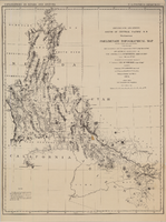
Map of explorations and surveys south of the Central Pacific Railroad made by the U.S. Army Corps of Topographical Engineers, 1871
Date
1871
Description
'Preliminary topographical map embracing in skeleton a portion only of the notes from surveys made in accordance with Par.II Special Orders No. 109 War Dept., March 18th, 1871 and letter of instructions of Brig. General A.A. Humphreys, Chief of Eng'rs. dated March 23rd, 1871. Conducted under the immediate direction of 1st Lieutenant Geo. M. Wheeler, Corps of Eng'rs., assisted by 1st Lieutenant D.W. Lockwood, Corps of Eng'rs. and 2nd Lieutentant D.A. Lyle, 2nd U.S. Artillery, during the summer and fall of 1871. Louis Nell, chief topographer and draughtsman.'' At head of map: 'Explorations in Nevada and Arizona. U.S. Engineer Department.' In lower left corner: 'Note: This map is a hasty and partial compilation from the topographical data already received, many still remaining en route. Upon it is projected in skeleton the groundwork of the area examined. All points except the prominent astronomical positiions are subject to lsight modification upon the final map.' Shows area through central Nevada, eastern California, and central Arizona. Relief shown by hachures. Published by the War Dept. Scale [ca. 1:1,520,640]. 1 in. to 24 miles (W 118°--W 109°/N 41°--N 32°).
Image
Topographic map of Las Vegas Rancho, showing location of wells and water lines, Las Vegas, Nev., May 1, 1940
Date
1940-05-01
Description
'May 1, 1940.' 'F-225.' Relief shown by contours. Scale [ca. 1:7,200] 1 in.=600 feet. Blueprint.
Image
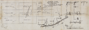
Fairday Mine property map, May 25, 1916
Date
1916-05-25
Description
'Fairday Mine, Cactus Range, Nye Co., Nev. property map showing vein outcrops and underground surface, May 25, 1916.' Handwritten in lower left corner: 'Map property of A.H. Lee, care [of] Tonopah Club, Tonopah, Nev.' 'Scale 200' to the inch.' 'Silver oz. Gold value 1/9.'
Image

Map of the Las Vegas Strip, 1953
Date
1953
Description
Scale [ca. 1:9,600. 1 in. to approx. 800 ft.] ; 1 map : col. ; 57 x 29 cm ; Cadastral map ; Campbell Realty Company.
Image