Search Results
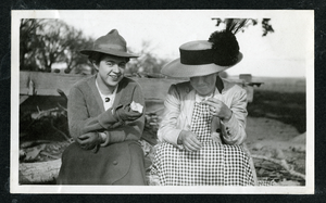
Black-and-white photograph of two women wearing hats while sitting outdoors, Las Vegas (Nev.), 1900-1925
Date
1900 to 1925
Archival Collection
Description
Photograph of two women wearting hats while sitting outdoors, Las Vegas (Nev.), 1900-1925
Image
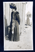
Black-and-white photograph of a woman wearing a fox fur, Goldfield (Nev.), 1900-1920
Date
1900 to 1920
Archival Collection
Description
Photograph of a woman wearing a fox fur, Goldfield (Nev.), 1900-1920
Image
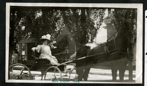
Black-and-white photograph of a woman driving a carriage in town, Las Vegas (Nev.), 1908
Date
1908
Archival Collection
Description
Inscription on front reads: "Mrs. Dugan 1908"
Caption: Mrs. Dugan, 1908
Image
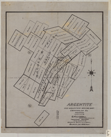
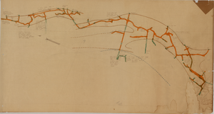
Map of Argentite: Red Mountain Mining District, Esmeralda County (Nev.),1908
Date
1908
Description
Scale [ca. 1:7,200]. 1 in. equals 600 feet ; 1 map : linen ; 46 x 39 cm
Image
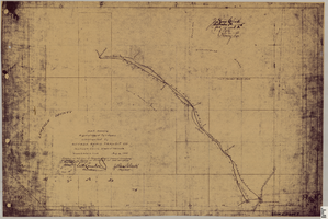
Map showing right of way of toll road constructed by Nevada Rapid Transit Co. in Lincoln County (Nev.), 1905
Date
1905
Description
Scale [ca. 126,720]. 1 in.=2 miles 1 map : blueline print ; 49 x 74 cmScale [ca. 126,720]. 1 in.=2 miles ; 1 map : blueline print ; 49 x 74 cm ; Shows right of way of what now is Interstate 95 through what is now Clark County, Nevada ; "Aug. 10, 1905." ; "Adopted as toll road of Nevada Rapid Transit Company at meeting of Board of Directors of said company Aug. 25, 1905. Attest Wh. Comstock, secretary, J. Ross Clark, president." ; "Book I, page 3"--Lower right corner of map ; "[Illegible] recording [illegible] J. Ross Clark September 1st. A.D. 1905 at 40 [illegible] 8 A in book of platts [illegible] Henry Lee [illegible]"--Upper right portion of map
Image
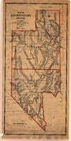
Map of Lincoln County (Nev.), 1908
Date
1908
Description
Scale [ca. 1:380,160]. 1 in. to approx. 6 miles (W 116 --W 114 /N 39 --N 35 ) ; 1 map : hand col., mounted on linen ; 115 x 54 cm ; Relief shown by hachures and spot heights ; Hand colored ; Shows range and township grid ; Shows towns, railroads, proposed railroads, wagon roads and springs ;
Image
Map of the Red Top Mine, 4th level, Esmeralda County (Nev.), 1900-1925
Date
1900 to 1925
Description
Sectional mining map; hand-drawn and annotated in colored pencil
Image
Map of the Combination Mine, 280 ft., Esmeralda County (Nev.), 1900-1925
Date
1900 to 1925
Description
Sectional mining map; hand-drawn and annotated in colored pencil
Image
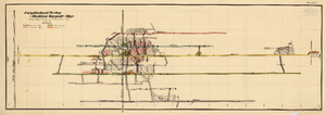
Map of the Longitudinal Section, Montana Tonopah Mine, Nye County (Nev.), 1900-1925
Date
1900 to 1925
Description
Map of the Longitudinal Section, Montana Tonopah Mine, Nye County (Nev.), 1900-1925
Image
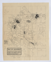
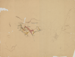
Photograph of plat map of principal Goldfield mines, Goldfield (Nev.), late 1800s
Date
Unknown year in the decade of the 1890s (year uncertain)
Description
Caption: This plat shows the principal mines of Goldfield. The five groups in which the Goldfield-Majestic Mines Company is interested are marked in black.
Image