Search Results
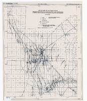
Map of part of Las Vegas Valley showing the piezometric surface of the "near-surface" water during the spring of 1946 by contours, and areas of discharge by evaporation and transpiration
Date
1946
Description
Relief shown by contours. Includes range and township grid. Shows springs, wells and areas of discharge. Scale [ca. 1:67,162. 1 in. to approx. 1.06 miles]. Series: Water resources bulletin (Carson City, Nev.)
no. 5. Originally published as plate 7 in Geology and water resources of Las Vegas, Pahrump, and Indian Spring Valleys, Clark and Nye Counties, Nevada by George B. Maxey and C.H. Jameson, which is number 5 of the Water resources bulletin published by the Nevada Office of the State Engineer.
Image
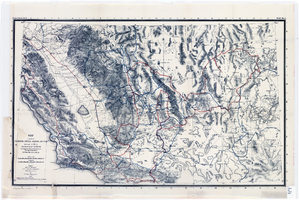
Map of parts of California, Nevada, Arizona and Utah : traversed in 1891 by the Death Valley Expedition (a biological survey conducted by the U.S. Dept. of Agriculture), C. Hart Merriam in charge
Date
1893
Description
Scale [ca. 1:1,267,200. 1 in. to approx. 20 miles] (W 122°00--W 113°00/N 38°30--N 34°00) ; 1 map : col. ; 42 x 69 cm., folded to 22 x 12 cm ; Relief shown by hachures and spot heights ; From: The Death Valley Expedition. Part II. 1893. North American fauna, no. 7 ; "Routes of Dr. C. Hart Merriam" and "Distinctive routes of other members of the expedition" overprinted in color ; Map was compiled in 1892 ; "Map no. 1."--Upper right corner ; Government Printing Office
Image
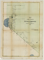
Map of public surveys in Nevada Territory to accompany report of Surveyor General, October 1, 1862
Date
1862-10-01
Description
'Surveyor Generals Office. San Francisco California October 1st 1862. [signed] E.F. Beale, U.S. Surv. Genl. Nevada Terry.' In upper right corner: 'Ho. Reps. Ex. Doc. No. 1. 37th Cong. 3d. Sess.' Relief shown by hachures. Scale [1:253,440] 1 in. to 4 miles (W 120°08--W 118°40/N 39°45--N 38°00)
Image
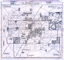
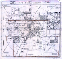
Map of the city of Las Vegas and vicinity, Clark County, Nevada, 1929
Date
1929
Description
'Copyright 1929, C.D. Baker, civil engineer. Drawn by R.C. Kenmir.' Includes inset sketch showing general location of Las Vegas, Nev. Relief shown pictorially on inset map. Scale [ca. 1:39,600. 1 in. to 0.625 mile]. Cadastral map. Library's copy 1 has hand-drawn brown line and red circles. Library's copy 2 has "Proposed annexation" printed in capital letters in red pencil near the top, has a brown line drawn around the area.
Image
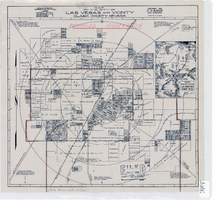
Map of the city of Las Vegas, Nevada, March 1, 1927
Date
1927-03-01
Description
'Compiled by C.D. Baker, civil eningeer. 220 Fremont St. March 1, 1927.' 'C.E. Pembroke, selling agent.' Scale [ca. 1:3,600]. 1 in. to 300 ft. Cadastral map. Blueline print.
Image
Map of the state of Nevada, 1886
Date
1886
Description
'Compiled by John W. Parker, chief draughtsman of the U.S. Sur. General's Office, Reno, Nevada, from official maps on file on the office, War Department maps and other reliable data. 1886.' 'Entered according to act of Congress, in the year 1886, by John W. Parker, in the office of the Librarian of Congress at Washington.' Relief shown by hachures. Shows townships, including which townships are subdivided, roads, railroads, Indian reservations, etc. Shows range and township grid. Scale [1:760,320]. 1 in. to 12 miles (W 120°--W 114°/N 42°--N 35°).
Image

Map of the state of Nevada to accompany the annual report of the Commr. Genl. Land Office, October 2, 1866
Date
1866-10-02
Description
'Department of the Interior, General Land Office, October 2nd, 1886, [signed] Jos. S. Wilson, Commissioner.' 'The Major & Knapp Eng. Mfg. & Lith. Co. 71 Broadway, N.Y.' Relief shown by hachures. Hand colored. Shows silver, gold, and copper mines. Scale [1:1,140,480]. 18 miles to an in. (W 120°--W 114°/N 42°--N 35°)
Image
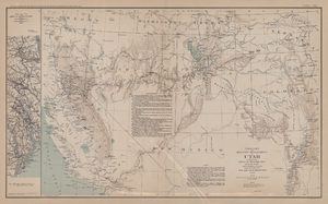
Map of territory and military department of Utah, 1860
Date
1860
Description
Compiled in the Bureau of Topographical Engineers of the War Department. Chiefly for Military purposes under the authority of Honorable J.B. Floyd, Secretary of War, 1860. 42 x 69 cm. Shows towns, wagon roads, explorers' routes, railroads, forts, etc., approx. from Albuquerque, N.M. to Fort Lane, Or. and from Fort Laramie, Wyo. to Los Angeles, Calif. "Corrections and additions in reference to railroads in California, etc., were made in January, 1862 ..." "The new military posts at Fort Bidwell, ... located from a map loaned ... January 16, 1866." "Atlas to accompany the official records of the Union and Confederate armies, 1861-1865. Plate CXX."--Upper margin. Atlas published by the Washington Government Printing Office in 1891-95. Relief shown by hachures. "Julius Bien & Co. Lith. N.Y." Includes text and list of authorities. Inset: March routes of Army of the Tennessee from Savannah, Ga., to Columbia, S.C., 1865, accompanying the report of Maj. Gen O.O. Howard, U.S. Army, series I, vol. XLVII, part I. Includes bibliographical references. Washington Territory is shown prior to becoming Washington state. The geographic region of Southwest is referred to as the New Southwest. Original publisher: Govt. Print. Off..
Image