Search Results
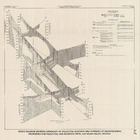
Fence diagram showing lithology of valley-fill deposits and summary of water-bearing properties for valley-fill and bedrock units, Las Vegas Valley, Nevada, 1981 (Water-supply paper 2320-A)
Date
1981
Description
'Department of the Interior, U.S. Geological Survey. Water-supply paper 2320-A, plate 2.' 'Prepared in cooperation with the Clark County Department of Comprehensive Planning.' 'Geology by R.W. Plume, 1981.' Scale [ca. 1:95,040. 1 in.=approx. 1.5 miles]. Series: U.S. Geological Survey water-supply paper2320-A. Originally published as plate 2 of Ground-water conditions in Las Vegas Valley, Clark County, Nevada. Part I. Hydrogeologic framework / by Russell W. Plume, published by the U.S. Geological Survey in 1989 as Water-supply paper 2320-A. "Prepared in cooperation with the Clark County Department of Comprehensive Planning."
Text
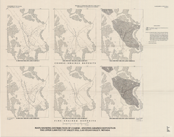
Maps showing distribution of coarse- and fine-grained deposits in the upper 1,000 feet of valley fill, Las Vegas Valley, Nevada, 1981 (Water-supply paper 2320-A, plate 3)
Date
1981
Description
'Department of Interior, U.S. Geological Survey. Water-supply paper 2320-A, plate 3.' 'Prepared in cooperation with the Clark County Department of Comprehensive Planning.' 'Base from U.S. Geological Survey, 1:250,000, Las Vegas and Kingman, 1969.' 'Geology from Malmberg (1965); Longwell and others (1965); and J. R. Harrill, 1976. Lithology by R.W. Plume, 1981.' Contents: Coarse-grained deposits: 0-200 feet below land surface; 200-700 feet below land surface; 700-1,000 feet below land surface -- Fine-grained deposits: 0-200 feet below land surface; 200-700 feet below land surface; 700-1,000 feet below land surface. Scale [ca. 1:316,800. 1 in.=approx. 5 miles]. Series: U.S. Geological Survey water-supply paper2320-A. Originally published as plate 3 of Ground-water conditions in Las Vegas Valley, Clark County, Nevada. Part I. Hydrogeologic framework / by Russell W. Plume, published by the U.S. Geological Survey in 1989 as Water-supply paper 2320-A.United States Dept. of the Interior, Geological Survey.
Image
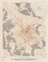
Index map showing locations of geologic sections on plate 2 and wells on plates 2 and 3, Las Vegas Valley, Nevada, 1981 (Water-supply paper 2320-A)
Date
1981
Description
'Department of the Interior, U.S. Geological Survey. Water-supply paper 2320-a, plate 4.' 'Prepared in cooperation with the Clark County Department of Comprehensive Planning.' 'Base from U.S. Geological Survey 1:100,000 , Boulder City, Ariz.-Nev., Las Vegas, Nev.-Calif., Mesquite Lake, Nev.-Calif., 1978, Lake Mead, Nev.-Ariz., 1979.' 'Geology from Malmberg (1965); Longwell and others (1965); Bell and Smith (1980); and J. R. Harrill, 1976.' Shows township and range lines. Scale 1:100,000 (W 115°30´--W 115°00´/N 36°30´--N 36°00´). Series: U.S. Geological Survey water-supply paper2320-A. Originally published as plate 4 of Ground-water conditions in Las Vegas Valley, Clark County, Nevada. Part I. Hydrogeologic framework / by Russell W. Plume, published by the U.S. Geological Survey in 1989 as Water-supply paper 2320-A.
Image
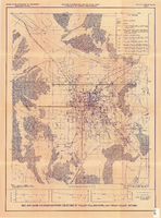
Map and basin profiles showing thickness of valley-fill deposits, Las Vegas Valley, Nevada, 1981
Date
1981
Description
At top of map: 'United States Department of the Interior. Geological Survey. Open-file report 84-130, plate 5.' 'Prepared in cooperation with the Clark County Department of Comprehensive Planning.' At bottom of map: 'Base from U.S. Geological Survey, 1:100,000, Boulder City, Ariz.-Nev., Las Vegas, Nev.-Calif., Mesquite Lake, Nev.-Calif., 1978; Lake Mead, Nev.-Ariz., 1979.' 'Geology from Malmberg (1965); Longwell and others (1965); Haynes (1967); Bell and Smith (1980); Bell (1981) and J. R. Harrill, 1976. Thickness of valley-fill deposits by R.W. Plume, 1981.' Includes three profiles. Shows township and range lines. Scale [ca. 1:95.040. 1 in.=approx. 1.5 miles] (W 115°30´--W 115°00´/N 36°30´--N 36°00´). Series: Open-file report (Geological Survey (U.S.)), 84-130. Originally published as plate 5 of Ground-water conditions in Las Vegas Valley, Clark County, Nevada. Part I. Hydrogeologic framework / by Russell W. Plume, published by the U.S. Geological Survey in 1984 as Open-file report 84-130.
Image
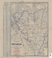
Sketch map of Nevada and the southeastern portion of California, 1906
Date
1906
Description
1907 written in red pencil at top of map. 41 x 29 cm. Relief shown by hachures. Copyright held by George S. Clason. Includes index. "Compliments of A.E. Holt, real estate and mines, Bullfrog Mining Dist., Rhyolite, Nevada." Red star indicates location of A.E. Holt company. Shows railroad routes. Library's copy has "1907" printed with brown crayon in upper margin and has four sets of two holes punched in a vertical line along the right third of the map. Original publisher: Clason Map Co..
Image
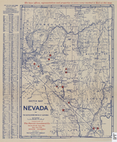
Sketch map of Nevada and the southeastern portion of California, 1906
Date
1906
Description
42 x 29 cm. Relief shown by hachures. Copyright held by George S. Clason. "Compliments of the Patrick Investment Co. ... Denver, Colorado." Includes index. Shows railroad routes. "We have offices, representatives and properties in every camp marked in red on this map." Original publisher: Clason Map Co..
Image
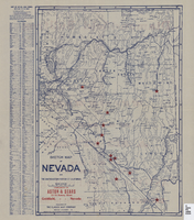
Sketch map of Nevada and the southeastern portion of California, 1906
Date
1906
Description
41 x 29 cm. Relief shown by hachures. Copyright held by George S. Clason. Includes index. "Compliments of Aston & Sears ... Goldfield, Nevada." Red stars probably indicate location of towns with either offices of or claims owned by Aston & Sears. Shows railroad routes. Ad for shares in the Diamond Bullfrog claim on verso. Original publisher: Clason Map Co..
Image


Map showing general geology and areas of artesian flow of the Las Vegas, Pahrump, and Indian Spring Valleys, Clark and Nye Counties, Nevada, 1946
Date
1947
Description
'United States Department of Interior, Geological Survey, Water Resources Bulletin No. 6.' 'State Engineer of Nevada.' Relief shown by contours. Includes township and range lines. Scale [ca. 1:126,720. 1 in.=approx. 2 miles]. Series: Water resources bulletin (Carson City, Nev.)no. 6. Originally published as plate 1 in Ground water in Las Vegas, Pahrump, and Indian Spring Valleys, Nevada : a summary / G. B. Maxey and T. W. Robinson, prepared in cooperation with the United States Department of the Interior, Geological Survey, and published as no. 6 of the Water resources bulletin.
Image