Search Results

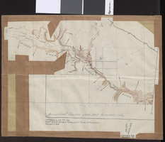
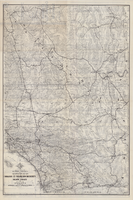
Topographic map of Arrow Canyon dam and reservoir site on the Muddy River, 1934
Date
1934
Archival Collection
Description
'Topography by Lee Morrison. Control by U.S. Geological Survey and U.S. Bureau of Reclamation. Surveyed in 1934.' Relief shown by contours and spot heights. 'Arrowhead Canyon Dam and reservoir site' hand-written on map. Map is part of a larger map and has been taped to a manila envelope sent from the Agricultural Administration to J.H. Wittwer on Sept. 25, 1939. Map has hand-drawn township and range lines and handwritten numbers. Verso has a hand-drawn map, calculations, and hand-written notes. U.S. Geological Survey
Text
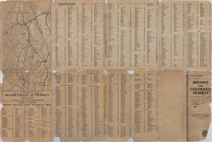
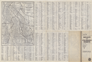
Map of a portion of southern California and southwestern Nevada embracing the arid region of Mojave & Colorado Deserts including Death Valley, circa 1937
Date
1937 (year approximate)
Description
79 x 52 cm. Panel title: Road map of the Mojave and Colorado Deserts including Death Valley National Monument. Index on verso. Relief shown by hachures and spot heights. In lower right-hand corner: Burke Douglas Pflum. "3712."--Lower left-hand corner of copy 1. "C13247."--Lower left-hand corner of copy 2. "1379."--Lower right-hand corner. Originally folded to 28 x 11 cm. On verso: Map showing roads and points of interest in Death Valley and vicinity. Original publisher: The Club.
Image
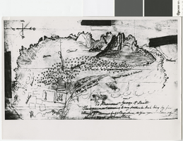
Hand-drawn map of the Mormon Fort and Las Vegas Valley from a letter by John Steele to Brigham Young, circa 1855
Date
1850 to 1859
Archival Collection
Description
Hand-drawn map showing area around the Mormon Fort in Las Vegas, Nevada, circa 1855. Handwritten in lower right: 'To President George A. Smith. This is drawn not according to any particular rule being my first attempt at drawing but it may serve to give you an idea of the Las Vegas. John Steele.' Copy print of material in LDS Archives. Scale not given..
Image

Map of farm plots of the Las Vegas Mormon Mission, 1855
Date
1855
Archival Collection
Description
Copy print of material in LDS Archives. Scale not given.
Image
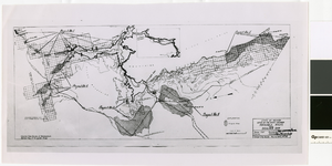
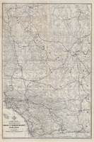
Map of irrigable areas near Boulder Dam, February 20, 1935
Date
1935-02-20
Archival Collection
Description
'Drawn by C.G.C.' 'Carson City, Nevada, Feb. 20, 1935. No. 4.' 'Adapted from Bureau of Reclamation's General map of irrigable areas.'
Image