Search Results
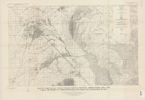
Map of part of Las Vegas Valley, Nevada, showing approximate area and areal densities of phreatophytes and areas in cultivation in 1912
Date
1965
Description
Genre/Form: Thematic maps. Scale 1:62,500 (W 115°15´--W 114°45´/N 36°15´--N 36°00´). 1 map : col. ; 45 x 72 cm. Series: Water-supply paper (Washington, D.C.) ; 1780. Relief shown by contours. Originally published as plate 11 of Available water supply of the Las Vegas ground-water basin, Nevada, by Glenn T. Malmberg, published by the Geological Survey in 1965 as its Water-supply paper 1780. Includes township and range lines. Interior, Geological Survey
Image
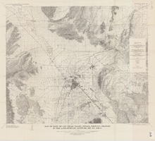
Map of part of Las Vegas Valley, Nevada, showing changes in the land-surface altitude, 1935-50
Date
1965
Description
Genre/Form: Topographic maps. Scale 1:96,000 (W 115°30´--W 114°45´/N 36°30´--N 36°00´). 1 map ; 58 x 70 cm. Series: Water-supply paper (Washington, D.C.) ; 1780. Relief shown by contours. "After Smith, Vetter, Cummings, and others (1960, p. 34)." Originally published as plate 13 of Available water supply of the Las Vegas ground-water basin, Nevada, by Glenn T. Malmberg, published by the Geological Survey in 1965 as its Water-supply paper 1780. Includes township and range lines. Interior, Geological Survey
Image
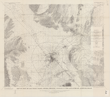
Map of part of Las Vegas Valley, Nevada, showing changes in the land-surface altitude, 1935 to 1940-41
Date
1965
Description
Genre/Form: Topographic map. Scale 1:96,000 (W 115°30´--W 114°45´/N 36°30´--N 36°00´). 1 map ; 58 x 70 cm. Series: Water-supply paper (Washington, D.C.) ; 1780. Relief shown by contours. "After C.R. Longwell (written communication, 1954, fig. 30)." Originally published as plate 12 of Available water supply of the Las Vegas ground-water basin, Nevada, by Glenn T. Malmberg, published by the Geological Survey in 1965 as its Water-supply paper 1780. Includes township and range lines. Interior, Geological Survey
Image
Map showing estimated average recharge to and discharge from ground-water reservoirs by basins, and hydraulic potential in Clark and Nye counties, Nevada, 1963
Date
1963
Description
'T.E. Eakin, S.L. Schoff, and P. Cohen, 1963.' 'Department of the Interior, United States Geological Survey, TEI-833.' 'Prepared in cooperation with the U.S. Atomic Energy Commission.' Scale 1:500,000 (W 117°30´--W 115°00´/N 38°30´--N 36°30´). Originally published as figure 2 in Regional hydrology of a part of southern Nevada : a reconnaissance / by Thomas E. Eakin, Stuart L. Schoff, and Philip Cohen, published by the U.S. Geological Survey in 1963 as number 833 of the Trace elements investigation report.
Image
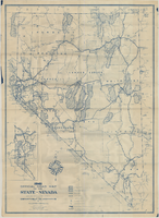
Official road map of the State of Nevada, 1941
Date
1941
Archival Collection
Description
Compiled and published for free distribution by the Department of Highways, Carson City, Nevada. Board of Directors: Governor E.P. Carville, Chairman; Gray Mashburn, Member; Henry Schmidt, Member; Robert A. Allen, State Highway Engineer. Nevada Department of Highways
Image
Maps of geographical surveys of parts of California, southeastern Nevada, Arizona and southwestern Utah, made under the command of George M. Wheeler, 1872-1873
Date
1872 to 1873
Description
At top of plate: 'U.S. geographical surveys west of the one-hundredth meridian. Parts of California, S.E. Nevada, Arizona & S.W. Utah.' At bottom of plate: 'Expeditions of 1872 & 1873, under the command of 1st Lieut. Geo. M. Wheeler, Corps of Engineers, U.S. Army.' 'G. K. Gilbert, A. R. Marvine, E. E. Howell, geological assistants.' 'By order of The Honorable The Secretary of War, under the direction of Brig. Gen. A. A. Humphries, Chief of Engineers, U.S. Army.' Published by Government Printing Office. 2 map sections on 1 sheet. Scale: 1 inch to 8 miles.
Image
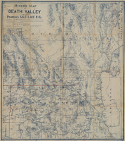
Miners map of Death Valley and the proposed Salt Lake railroads, January 1903
Date
1903-01
Description
Subtitle: 'Including portions of San Bernardino and Inyo Counties, California; Nye and Lincoln Counties, Nevada and Mojave County, Arizona.' 'Compiled and drawn by A. Russell Crowell.' 'May 1902 (Corrected to Jan. 1903.' 'Property of H. Kehoe' written in ink in upper left corner. Scale [ca. 1:506,880]. 1 in. to 8 miles (W 118?--W 114?/N 38?--N 35?). Relief shown by hachures and spot heights. Blueline print. Library's copy has types of minerals found in different areas hand-printed in red and has red lines hand-drawn along county boundaries. G4351.H1 1903 .C76
Image

General highway base map, state of Nevada, 1975
Date
1975
Description
'Prepared by Nevada State Highway Department, Planning Survey Division, in cooperation with U.S. Department of Transportation, Federal Highway Administration.' 'Copyright Nevada State Highway Department.' 'Transverse mercator projection. Mount Diablo base and meridian. 50,000 meter universal transverse mercator grid zone 11.' Insets of Reno-Sparks area, Las Vegas area, Lake Tahoe area. 29-H53/21:N41-1975.
Image

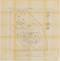
Map of Las Vegas, Nevada and surrounding Bureau of Land Management areas to the west and north, 1994
Date
1994
Description
'BLM edition, 1994.' 'Surface management status; mineral management status.' '1:100,000-scale topographic map showing highways, roads and other manmade structures; water features; contours and elevations in meters with conversions to feet; BLM recreation sites.' 'Edited and published by the Bureau of Land Management. Base map prepared by the U.S. Geological Survey.' I53:11/4-2
Text
