Search Results
Nevada history
Level of Description
File
Archival Collection
Scott Rayer Collection of Television Programs about Las Vegas, Nevada
To request this item in person:
Collection Number: MS-01130
Collection Name: Scott Rayer Collection of Television Programs about Las Vegas, Nevada
Box/Folder: N/A
Collection Name: Scott Rayer Collection of Television Programs about Las Vegas, Nevada
Box/Folder: N/A
Archival Component
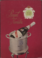
Royal Nevada wine list
Date
1950 (year approximate) to 1980 (year approximate)
Archival Collection
Description
Note: No date on menu Menu insert: Wine lists Restaurant: Royal Nevada Location: Las Vegas, Nevada, United States
Text
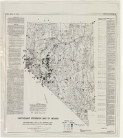
Earthquake epicenter map of Nevada, December 1964
Date
1964-12
Description
Scale 1:1,000,000 (W 120°--W 114°/N 42°--N 35°). Title in upper right margin: Earthquake epicenter map ; "Nevada earthquake epicenters for the period from about 1852 to 1961 are plotted on the accompanying map." ; "Contour interval 1,000 feet." ; "Supported by grant no. AF-AFOSR-62-285 of the Air Force of Scientific Research." ; "December 1964." ; "Base from NBM Map 17." ; "One million scale set." ; Includes bibliographical references ; Includes text and index. Nevada Bureau of Mines, University of Nevada
Text
Nevada Wildlife Federation Records
Identifier
MS-00400
Abstract
The Nevada Wildlife Federation Records (1989-1997) consist of pamphlets, newsletters, periodic meeting minutes, and a copy of the bylaws of the Nevada Wildlife Federation.
Archival Collection

A Nevada Desert Experience sign: photographic print
Date
1980 (year approximate) to 2000 (year approximate)
Archival Collection
Description
A protest at the Nevada Test Site circa 1980-1999. The sign reads "Nevada Desert Experience" with a picture of a dove flying over the state of Nevada.
Image
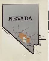
Map of Nevada Test Site: photographic print
Date
1945-19-82
Archival Collection
Description
Map of Nevada showing Nevada Test Site.
Image

Tectonic map of Clark County, Nevada, 1965
Date
1965
Description
'Nevada Bureau of Mines. Bulletin 62, plate 5.' 'Prepared cooperatively by the U.S. Geological Survey.' Shows types of rocks as well as faults. Scale [ca. 1:760,320. 1 in. to approx. 12 miles] (W 116°--W 114°/N 37°--N 35°). Bulletin (Nevada Bureau of Mines)62.
Image
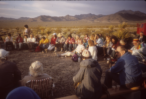
Protesters seated in the desert at Nevada Test Site, Nevada: photographic slide
Date
1987-04
Archival Collection
Description
From the Sister Klaryta Antoszewska Photograph Collection (PH-00352). Demonstration at Nevada Test Site
Image
Education in Nevada
Level of Description
File
Archival Collection
Zelvin Lowman Papers
To request this item in person:
Collection Number: MS-00184
Collection Name: Zelvin Lowman Papers
Box/Folder: N/A
Collection Name: Zelvin Lowman Papers
Box/Folder: N/A
Archival Component