Search Results

Maps showing sales of water production facilities of the Union Pacific Railroad Company and water distribution facilities of the Las Vegas Land and Water Co. to the Las Vegas Valley Water District, April 29, 1953
Date
1953
Archival Collection
Description
Union Pacific Railroad Co.
Image
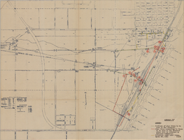
Map showing locations of water bearing lands to be sold to the Las Vegas Valley Water District and boundaries of lands owned by the Union Pacific Railroad not to be sold to the District, April 29,1953
Date
1953-04-29
Description
'Exhibit A. Location of water bearing lands to be sold to the District. Boundary of lands owned by Union Pacific which are not to be sold to the District. April 29, 1953. I-128'
Image
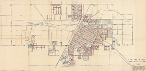
Map showing facilities of the Las Vegas Land and Water Co. completed, under construction and commenced after September 1, 1952
Date
1953-04-29
Description
'Exhibit D. Facilities of Water Company completed as of September 1, 1952. Facilities of Water Company under construction as of September 1, 1952. Facilities of Water Company which were commenced after September 1, 1952, and prior to March 1, 1954. April 29, 1953. I-67.'
Image
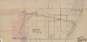
Map showing water pipelines to be sold to the Las Vegas Valley Water District, those to be retained by the Union Pacific Railroad Company, and privately owned pipelines, April 29, 1953
Date
1953-04-29
Description
'Exhibit H. Portions of pipe lines to be sold to the District. Pipe lines connecting to those to be sold to the District which will be retained by Railroad Companies. privately owned pipe lines. April 29, 1953. I-128.'
Image
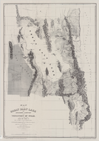
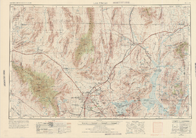
Map of the Great Salt Lake and adjacent country in the territory of Utah, 1852
Date
1852
Description
85 x 58 cm. "Available from the University of Utah Press, Salt Lake City, Utah 84112." Relief shown by hachures and spot heights; depths shown by soundings. "Scale 1:240,000"--inapplicable due to reproduction. Originally published to accompany Stansbury's report, Exploration and survey of the valley of the Great Salt Lake of Utah published in 1852 for the United States Army's Corps of Topographical Engineers. Includes text. Original publisher: University of Utah Press, Scale 1:240,000.
Image
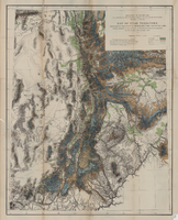
Map of Utah territory representing the extent of the irrigable, timber and pasture lands, 1878
Date
1878
Description
90 x 71 cm. Relief shown by hachures. In bottom margin: "Julius Bien, Lith." "Note. This map has been constructed from atlas sheets of the U.S. Geographical and Geological Survey of the Rocky Mountain Region with additional material taken from the maps of the U.S. Geographical Explorations and Surveys west of the 100th meridian, Lieut. Geo. M. Wheeler, Corps of Engineers, in charge ; the U.S. Geological Exploration of the 40th parallel, Clarence King, U.S. Geologist in charge ; and the U.S. Geologial and Geographical Survey of the Territories, F.V. Hayden, in charge." At head of title: Department of the Interior, U.S. Geographical and Geological Survey of the Rocky Mountain region, J.W. Powell in charge. Original publisher unknown.
Image

Map showing plan for water quality management update for wastewater collection systems in the Las Vegas Valley, February 20, 1997
Date
1997-02-20
Description
'Plate 1. Source: Clark County Geographic Information Systems Central Repository. Comprehensive Planning, Advanced Planning Division. Feburary 20, 1997.' Scale [ca. 1:95, 040. 1 in.=approx. 1.5 miles]. Shows sewers, force mains, service area boundaries, watershed boundaries, and lift stations. Includes inset location map. Includes township and range grid. Clark County, Nevada, Comprehensive Planning, Advanced Planning Division.
Image
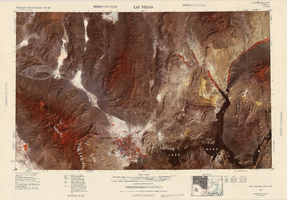
Satellite image map of the Las Vegas Valley, 1981
Date
1981
Description
'1981. Experimental edition 36114-A1-SI-250.' Scale 1:250,000 ; Transverse Mercator proj. (W 116°--W 114°/N 37°--N 36°). Series: Western United States 1:250,000. Western United States 1:250,000 ; NJ 11-12. Filing title: Las Vegas, Nev.; Ariz.; Calif. 'Imagery recorded with Multispectral Scanner (MSS) on NASA Landsat-3.' Includes image coverage diagram. Separate map on verso: Las Vegas / prepared by the U.S. Army Topographic Command ; revised by the U.S. Geological Survey 1969. Ed. 5. Washington, D.C. : Geological Survey, 1976, NJ 11-12 in the series Western United States 1:250,000. United States Geological Survey
Image