Search Results

Aerial photograph of downtown Las Vegas, Nevada, circa 1963
Date
1962 to 1964
Archival Collection
Description
Aerial photograph of downtown Las Vegas, Nevada looking southeast from the Union Pacific Railroad Station (curved Art Deco building in lower left). The Overland Hotel, Golden Gate, the Mint, Horseshoe Club, Hotel Fremont, Las Vegas Club and Golden Nugget are seen on Fremont Street.
Image

Aerial photograph of downtown Las Vegas, Nevada, circa 1963
Date
1962 to 1964
Archival Collection
Description
Aerial photograph of downtown Las Vegas, Nevada looking northeast towards Frenchman and Sunrise Mountains. The Overland Hotel, Golden Gate, Silver Palace, Hotel Fremont, The Mint, Silver Palace, Las Vegas Club, and Horseshoe Club on Fremont Street are visible in the center. The Union Pacific Railroad Station (curved Art Deco building) and tracks are in the bottom left of photo.
Image
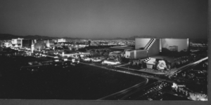
Photograph of the MGM Grand Las Vegas and hotels on Las Vegas Boulevard, Las Vegas, Nevada, circa 1993-1994
Date
1993 (year approximate)
Archival Collection
Description
A night view of the MGM Grand Las Vegas (with lion's head entrance) at the right, on the northeast corner of Las Vegas Boulevard and Tropicana Avenue, Las Vegas, Nevada. The Aladdin Hotel, Bally's and other properties are seen to the left.
Image
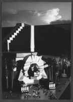
Photograph of the southeast entrance of the MGM Grand Las Vegas, Las Vegas, Nevada, circa 1993-1994
Date
1993 (year approximate)
Archival Collection
Description
The lion's head entrance to the MGM Grand Las Vegas Hotel and Casino (on the northeast corner of Las Vegas Boulevard and Tropicana Avenue), around the time of its opening on December 18, 1993.
Image
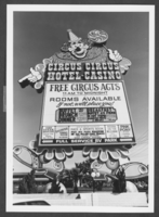
Photograph of the marquee of Circus Circus Hotel and Casino, Las Vegas, Nevada, circa 1970s-1980s
Date
1970 to 1989
Archival Collection
Description
The marquee on Las Vegas Boulevard (The Strip) in front of the Circus Circus Hotel and Casino in Las Vegas, Nevada.
Image
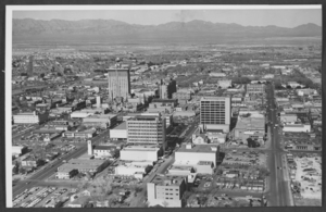
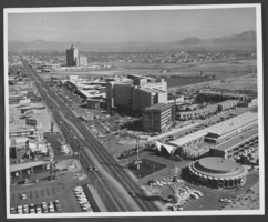
Photograph of downtown Las Vegas, Nevada, circa 1966
Date
1965 to 1967
Archival Collection
Description
An aerial view of downtown Las Vegas, Nevada, looking north. The northwest end of Fremont Street is at the center left side of the photograph. Fourth Street is seen near the right side of the photo. The Mint Hotel, Binion's Horseshoe Club, and the Golden Nugget on Fremont Street and the Clark County Courthouse on Second Street can be seen.
Image
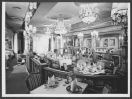
Photograph of the Bon Vivant Resturant, Circus Circus, Las Vegas, Nevada, circa 1970s
Date
1970 to 1979
Archival Collection
Description
The interior of the Bon Vivant, a restaurant on the mezzanine of the Circus Circus Hotel and Casino in Las Vegas, Nevada.
Image
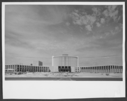
Photograph of construction on Caesars Palace, Las Vegas, Nevada, circa 1965-1966
Date
1965 to 1966
Archival Collection
Description
The eastern exterior of Caesars Palace in Las Vegas, Nevada, during construction.
Image
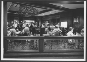
Photograph of Mamchen's Deli-Tavern, Las Vegas Hilton, Las Vegas, Nevada, circa 1970s-1980s
Date
1970 to 1989
Archival Collection
Description
Guests at Mamchen's Deli-Tavern in the Las Vegas Hilton, Las Vegas, Nevada. It overlooks the main casino.
Image
Photograph of hotels on Las Vegas Boulevard, Las Vegas, Nevada, circa 1966
Date
1965 to 1967
Archival Collection
Description
Partial view of the Las Vegas Strip looking northeast from north of Desert Inn Road in Las Vegas, Nevada. The El Rancho Vegas, Riviera, La Concha, and El Morocco Motel are visible on the right side of the photograph. The Westward Ho, Denny's Restaurant, and Satellite Motel are visible on the left. The Sahara Hotel is seen in the distance.
Image