Search Results
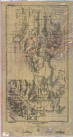
Map of a part of southern Nevada showing ground-water conditions, 1914
Date
1914
Description
At bottom of map: 'Base compiled from plane-table sheets, topographic maps of U.S. Geological Survey, railroad alignments, and General Land Office data.' Relief shown by hachures and spot heights. Shows township and range grid. Covers from southeast corner of White Pine County to Sloan and from Nye County border to Arizona-Utah border. Shows flowing wells, nonflowing wells, springs, flowing-well areas, dry holes and shore lines of ancient lakes. Scale 1:500,000 (W116°--W 114°/N 45°--N 36°). Series: Water-supply paper (Washington, D.C.), 365. Map is plate 1 from the U.S. Geological Survey water-supply paper 365.
Image
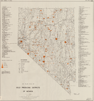
Map showing gold producing districts of Nevada, January 1967
Date
1967-01
Description
Scale 1:1,000,000. Series: Map (Nevada Bureau of Mines). 'January 1967.'
Text

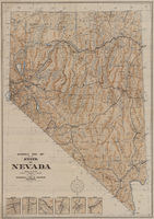
Automobile road map of the state of Nevada, circa 1930
Date
1930
Description
Insets of major roads in Reno, Carson City, Tonopah, Las Vegas, Winnemucca, and Ely at bottom left of map. 'Prepared by the Route and Map Service Department, Automobile Club of Southern California.' 'Copyrighted by the Automobile Club of Southern California.' Scale [ca. 1:1,013,760]. 1 in. to approx. 16 miles. Indexes on map verso.
Text

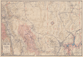
Map of desert area in southern Nevada and southeastern California, circa 1955
Date
1953 to 1957
Description
Covers the desert area in the Owens Valley, Death Valley, Las Vegas and Lake Mead region; bordered by Bishop and Inyokern, California, and Pioche and Lake Mead, Nevada. 'Cartography by W.T. Taylor, W.A. Neely. Color separation by H.P. Pflum; Relief by F.M. Burke; Typography by W.R. Williams. Field mapping by H.A. Cline, G.L. Boyd, K.R. Reed., W.A. Neely, R.P. Conklin.' 'Copyright by Automobile Club of Southern California.' Scale 1:483,537. 1 in. to approx. 8 miles (W 120°--W 114°/N 39°--N 33°). 'Map number 2217.'.
Text


Map showing location of the Las Vegas & Tonopah Railroad from Las Vegas to Bullfrog, Nevada, 1906
Date
1906
Archival Collection
Description
'Office of Chief Engineer' printed on map above date.
Image