Search Results
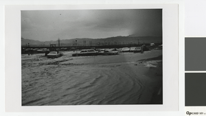
Photograph of flooding in a Las Vegas parking lot, circa 1970
Date
Archival Collection
Description
Flooding in a Las Vegas parking lot
Image
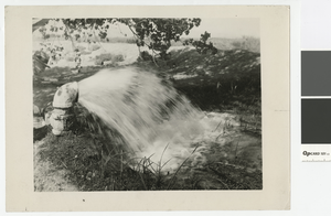
Photograph of artesian well throwing 60 inches of water, after 1950
Date
Archival Collection
Description
Man opening a valve to let an artesian well run
Transcribed Notes: Stamped on back: Vegas Studio, Las Vegas, Nevada; Handwritten inscription on back: Artesian well throwing 60 inches of water. Artesian wells average 400 ft. deep.
Image
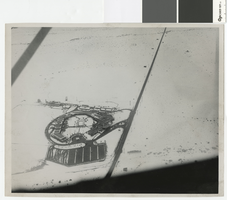
Aerial photograph of snow around the Flamingo Hotel, late 1940s
Date
Archival Collection
Description
Aerial view looking south of the Flamingo Hotel in the late 1940s. Note the snow on the ground.
Image
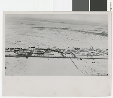
Aerial photograph snow around El Rancho Vegas, late 1940s
Date
Archival Collection
Description
Aerial view looking west of the El Rancho Vegas in the late 1940s. Note the snow on the ground.
Image
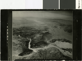
Aerial photograph of Black Canyon, Colorado River and Boulder City location before dam construction, 1920s
Date
Archival Collection
Description
Aerial view of Black Canyon, Colorado River, and Boulder City location before dam construction showing elevation.
Image
Photograph of two cars abandoned by their owners in St. Thomas, Nevada, April 11, 1948
Date
Archival Collection
Description
Remains of two cars, most likely near the remains of Hugh Lord's shop, in St Thomas, Nevada, when the town emerged from the waters of Lake Mead in 1945
Transcribed Notes: Bureau of Reclamation typed notes appended to back of photo: Boulder Canyon Project--Nevada--Region 3 St. Thomas, Nevada, was founded by the Mormons in 1855. In its heyday there were about 800 residents in the village. The "Main Street" was a part of the old Arrowhead Trail, which led from Salt Lake City, Utah to Los Angeles, California. In June 1938 the town was abandoned by its residents, which at that time were few in number because of the rising waters of Lake Mead that submerged the townsite. Photograph shows a closeup of two cars abandoned by their owners. Note the wide wooden wheel on the car to the right; also, the smaller wheel with wooden spokes. The wide wooden wheel was used as an "engine" to pump water, the belt being placed on this wooden wheel.
Image
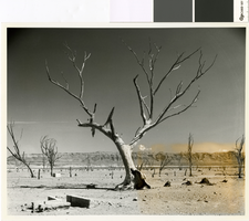
Photograph looking east through the remains of Saint Thomas, 1964
Date
Archival Collection
Description
Looking east through the remains of Saint Thomas from just south of Lord's Garage. Hannig's Ice Cream Parlor's remains are visible in the distance.
Image
Photograph looking west through the remains of Saint Thomas, March 25, 1964
Date
Archival Collection
Description
Looking west through the remains of Saint Thomas from near the remains of Jacob Baver's blacksmith shop.
Transcribed Notes: Bureau of Reclamation typed notes appended to back of photo: Townsite of St. Thomas, Nevada--Moapa Valley Project--Nevada A view of a portion of the townsite of St. Thomas, Nevada, settled by the Mormons in 1865, during a period of low water elevation in Lake Mead above Hoover Dam. The town was first covered by Lake Mead in June 1938.
Image
Photograph looking northwest through the remains of St. Thomas, March 25, 1964
Date
Archival Collection
Description
Looking northwest through the remains of St. Thomas towards the site of the Lost City
Transcribed Notes: Bureau of Reclamation typed notes appended to back of photo: Townsite of St. Thomas, Nevada--Moapa Valley Project--Nevada A view of a portion of the townsite of St. Thomas, Nevada, settled by the Mormons in 1865, during a period of low water elevation in Lake Mead, above Hoover Dam. The town was first covered by Lake Mead in June 1938.
Image
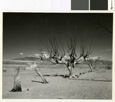
Photograph looking southeast through the remains of Saint Thomas, March 25, 1964
Date
Archival Collection
Description
Looking southeast through the remains of Saint Thomas with Lake Mead in the background.
Transcribed Notes: Bureau of Reclamation typed notes appended to back of photo: Townsite of St. Thomas, Nevada--Moapa Valley Project--Nevada A view of a portion of the townsite of St. Thomas, Nevada, settled by the Mormons in 1865, during a period of low water elevation in Lake Mead, above Hoover Dam. The town was first covered by Lake Mead in June 1938.
Image