Search Results
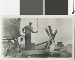
Photograph of a man working on a drilling rig, Taylor Ranch, before 1910
Date
Archival Collection
Description
Man working on a drilling rig at the Taylor Ranch.
Image
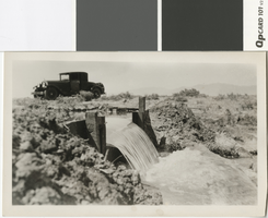
Photograph of irrigation headgate with water, before 1930
Date
Archival Collection
Description
Water flowing through an irrigation headgate.
Image
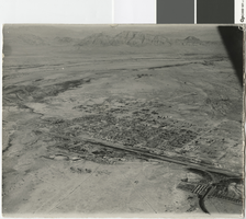
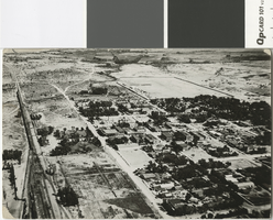
Aerial photograph of Union Pacific Railroad yards, Las Vegas, late 1920s
Date
Archival Collection
Description
Aerial view of Las Vegas and Union Pacific Railroad yards.
Transcribed Notes: Transcribed from back of photo: "[Identified by Dave Coons as LV Valley w/UPRR yards in Foreground. Late 1920s?] [Kim Geary - Roberts IDs ca 1931. EP 6-21-84]."
Image
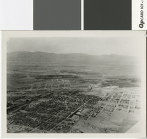
Aerial photograph of Las Vegas in the late 1920s
Date
Archival Collection
Description
Aerial view of Las Vegas, looking north.
Image
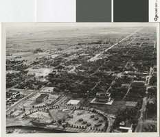
Aerial photograph of Las Vegas in the 1920s
Date
Archival Collection
Description
Aerial photograph of Las Vegas looking north.
Transcribed Notes: Transcribed from photo sleeve: "Aerial views of Las Vegas showing downtown UP yards 1920's. Shop's still standing (1983)."
Image
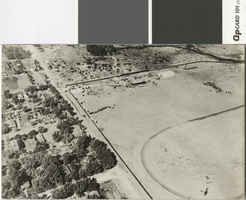
Aerial photograph of Las Vegas in the mid to late 1930s
Date
Archival Collection
Description
Aerial photo of Las Vegas looking south.
Transcribed Notes: Transcribed from photo sleeve: "[L. Foreground, old city hall. R. foreground, post office. Circular Park w/Boy scout structures (7)] "Aerial view of Las Vegas shows old park with race track (about where municipal swimming pool is) Small huts in group were Boy Scout huts made of stone. Scout troups met here surrounded by park taken middle or late 30's."- Dave Coons"
Image
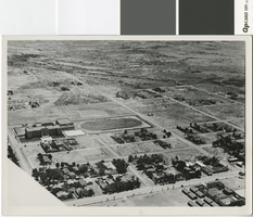
Aerial photograph of Las Vegas, taken since 1930
Date
Archival Collection
Description
Aerial photo of Las Vegas looking southeast, showing the high school and the LDS First Ward building.
Image
Aerial photograph taken of Dr. John S. Park home and Kiel Ranch, North Las Vegas, since 1920
Date
Archival Collection
Description
Aerial photograph of Kiel Ranch and the home of Dr. John S. Park.
Transcribed Notes: Transcribed from photo sleeve: "Dr. Park, A shot of your home taken from 800 feet. Buzz Morrison."
Image
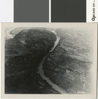
Aerial photograph taken of Black Canyon, before 1930
Date
Archival Collection
Description
Aerial view of Black Canyon prior to the construction of Hoover Dam
Image
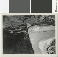
Aerial photograph of the Colorado River and Hemenway Wash, before 1935
Date
Archival Collection
Description
Hemenway Wash, located at the bend of the Colorado River just upstream of Black Canyon, before the construction of Hoover dam.
Transcribed Notes: Transcribed from back of photo: "Colorado River"
Image