Search Results

Map of Las Vegas Valley showing artesian wells, circa 1920
Date
1918 to 1922
Description
Scale not given ; 1 map ; 66 x 55 cm ; Blueline print ; Cadastral map ; Includes township and range grid ; Includes quotations McWilliams?
Image

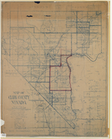
Map of Las Vegas Valley, Clark County, Nevada, 1954
Date
1954
Description
Scale [ca. 1:63,360. 1 in. to approx. 5,280 ft.].Cadastral map. 'Compiled for C.D. Baker, Reg. Civil Engineer Nevada No. 6 and Licensed Real Estate Broker by Tyson Engineering Co., Las Vegas, Nevada.' 'Copyright 1954 Tyson Engineering Co., Las Vegas, Nevada. Drawn by E.M. Ballinger' Tyson Engineering Company
Image
Map of a portion of southern California and southwestern Nevada, circa early 1930s
Date
1930 to 1934
Description
Subtitle: 'Embracing the arid region of Mojave & Colorado deserts including Death Valley.' In lower right-hand corner: '1379.' In lower left-hand corner: 'Burke-Douglas.' Relief shown by shading and spot heights. On verso: Indexes to cities, towns, junctions, resorts, springs, wells, tanks, waterholes, lakes, reservoirs, rivers and creeks, mountains, valleys, mines, canyons, passes, grades, deserts, flats and ranches. Includes mileage tables. 'Prepared by the Route and Map Service of the Automobile Club of Southern California'--Panel. On verso: Map showing roads and points of interest in Death Valley & vicinity. Scale [ca. 1:823,680]. 1 in. to approx. 13 miles (W 119°--W 114°/N 38°--N 33°)
Text


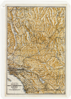
Map of an exploring expedition to the Rocky Mountains in the year 1842 and to Oregon & north California in the years 1843-44
Date
1845
Description
Scale 1:3,000,000. 47.35 miles to 1 in. (W 124°--W 94°/N 46°-- N 34°) ; 1 map ; 76 x 128 cm. ; Relief shown by hachures ; State 3: Includes notes, Great Basin statement, and place name South Park below Bayou Salade; some place names differ from other states ; Includes "Profile of the route from the mouth of the Kansas to the Pacific by Capt. J.C. Fremont in 1843." ; U.S. Senate
Image

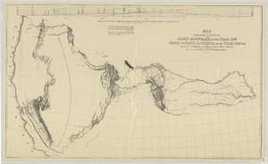
Map of Boulder Dam area and Las Vegas, Nevada, October 7, 1930
Date
1930-10-07
Description
'F.V. Owen, publisher ... Los Angeles, California. Topography by C.H. Fenner, C.E. Decorations by L.J. Bergère. Gov't. data, H.A. Shamberger, C.E. Copyright, 1930, by F.V. Owen.' At bottom right of map: 'Dated Oct. 7th, 1930.' Relief shown by contours and spot heights. Contour lines are 100 feet. Incudes six hand-colored illustrations showing local points of interest. Includes information on Hoover Dam, and chart of mileages from Las Vegas. Scale [ca. 1:63,360]. 1 inch to 1 mile
Text

Map of city of Las Vegas, Nevada, October 1, 1940
Date
1940-10-01
Description
'Compiled by C.D. Baker, Oct. 1, 1940.' Scale [ca. 1:11,400]. 1 in. to 950 ft. Cadastral map.
Image
Map of Clark County, Nevada, 1927
Date
1927
Description
'Compiled by J.T. McWilliams from official county records, U.S. Land Dept. surveys, railroad co. field maps and many personal surveys. Made in 1927 by J.T. McWilliams, C.E.' Includes township and road districts, school districts, mining districts, railroads, wagon roads, trails, springs and artesian wells. Scale [ca. 1:316,800. 1 in. to approx. 5 miles] (W 116°--W 114°/N37--N35). Relief shown by hachures. Blueline print. Library's copy 1 has one area outlined by hand in red. Library's copy 2 has school districts outlined in red and green pencil and labeled in pencil by hand.
Image
