Search Results
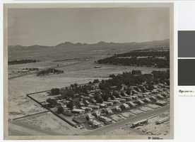
Aerial photograph of Las Vegas Boulevard and Nellis Boulevard, June 5, 1973
Date
Archival Collection
Description
Aerial view of Las Vegas Blvd. and Nellis Blvd looking north.
Transcribed Notes: Handwritten on back: "LV Blvd & Nellis Blvd looking north" Stamped on back: CNLV Engineering Dept"
Image
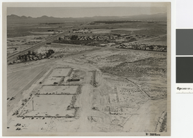
Aerial photograph of Las Vegas Blvd. and Cheyenne Ave., Las Vegas, June 5, 1973
Date
Archival Collection
Description
Aerial view of Las Vegas Blvd. and Cheyenne Avenue looking north.
Transcribed Notes: Transcribed from back of photo: "Building site of Safeway"
Image
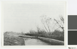
Photograph of Las Vegas Creek, Nevada, 1925
Date
Archival Collection
Description
Las Vegas Creek with what appears to be a wooden wire-wrapped pipeline running next to the creek.
Transcribed Notes: Transcribed from handwritten inscription on back of photo by Elizabeth Harrington: "Las Vegas Creek, formed by the overflow from one well that supplied the town of Las Vegas with its complete water supply for many years. This picture taken in 1925 near the head of the creek. Las Vegas Creek furnished a welcome playground for many youths, especially in the hot weather."
Image


Report, Flood control and soil conservation in southern Nevada
Date
Archival Collection
Description
Brief history of flooding along the Virgin River and a list of work undertaken to prevent or diminish future flooding.
Text
