
Search the Special Collections and Archives Portal

Search Results

Display    Results Per Page
Displaying results 160461 - 160470 of 830966

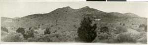
Photograph of hillside mines, Pioche (Nev.), early 1900s

Date

1900 to 1920

Description

Panorama of mines on the hillside. Tailings and mills can be seen on the top right.

Image

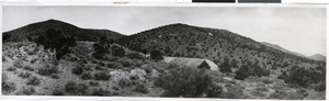
Photograph of mines, Pioche (Nev.), early 1900s

Date

1900 to 1920

Description

Panorama of mines on the hillside. Tailings from the mines can be seen along the mountain.

Image

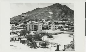
Photograph of Tonopah Midway Mine, Tonopah (Nev.), 1900-1920

Date

1900 to 1920

Description

Midway Mine, an underground minerals site in Tonopah, Nevada, is the potential location for silver to be mined. Black smoke rises from the smokestack with the site sitting atop a dirt surface. Written lightly in the center of the photograph reads "Midway Mine, Tonopah Nev." Site Name: Tonopah Midway Mine

Image

Photograph of Tonopah, (Nev.) 1900-1920

Date

1900 to 1920

Description

Tonopah, Nevada, with buildings scattered in the desert valley and moutains in the background. Appears mining is taking place in the front center of the photograph, possibly at the Tonopah Midway Mine or Belmont Mine. See Image 0141 0007 (pho023954) and Image 0141 0008 (snv001138) .

Image

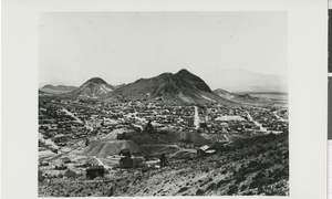
Photograph of Brougher Mt. and town, Tonopah (Nev.), 1900-1930

Date

1900 to 1930

Description

Tonopah looking toward Brougher Mountain. White "T" is visible in the left-center of the mountain. Inscription at bottom of photograph reads: "Tonopah Nevada"

Image

Photograph of school and houses, Tonopah (Nev.), 1930s

Date

1930 to 1939

Description

Tonopah school house and surrounding buildings in town. Houses identified: "First level of houses on hill behind schools: 1. Center, house with 3 Gables The Tasker Oddie House 2. Second house to right of Oddie House and largest structure on that level, the Hugh Brown house. House has a screened porch along whole front of house. Steps leading to porch are visible. Browns called it affectionately the ""Dobie Shack." 3. Eagle's nest on hill above Brown House and to right. 4. Large house with dormers lower half of photo was the Finn Boarding House in early Tonopah. 5. George Miller home next to Finn House. Miller the town barber. 6. Water tanks on hill to left."

Image

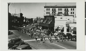
Photograph of marching band in streets, Tonopah (Nev.), 1920-1940

Date

1920 to 1940

Description

Parade walks through the streets of Tonopah, Nevada near "Butler Theater" and "Gloria's Beauty" Shop. Onlookers stand near the street as a band marches by while sign-holders and cars trails behind. Street Address: 100 South Main Street

Image

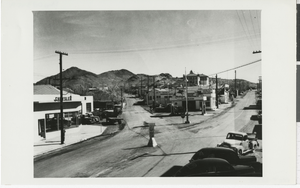
Photograph of Highway 95, Tonopah (Nev.), 1930s

Date

1930 to 1939

Description

Old Highway 95 "Y" road in Tonopah, Nevada. Left road is Florence Ave., and right road is Highway to Goldfield, Nevada. On the left side of Florence Ave. is a Dodge Chrysler dealership. Gas stations line the right side of Florence Ave. including Texaco and Mobil Socony-Vacuum Oil Company (now known as ExxonMobil). The sign in the center of the road reads: "Ely Wells Salt Lake" with an arrow pointing left, and "Goldfield Beatty Las Vegas" with an arrow pointing right. Street Address: 210 Florence Ave

Image

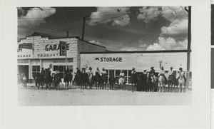
Photograph of horseback riders, Tonopah (Nev.), July 4, 1939

Date

1939-07-04

Description

People on horseback sit and stand in front of Mizpah Garage, an automobile service station. The seventh person mounted from the left identified as Phyllis Henderson, and the other riders are unknown. Signs hanging from garage read "Authorized Distributor Standard Stations Inc. Mizpah Garage" and "Mizpah Garage." Street Address: North Main Street

Image

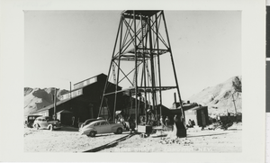
Photograph of mine shaft, Tonopah (Nev.), 1930s

Date

1930 to 1939

Description

Miners stand near large mine shaft in Tonopah, Nevada. Cars are parked in the dirt near a building next to the mining entrance at the surface, and mountains are visible in the background.

Image