Search Results

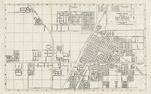
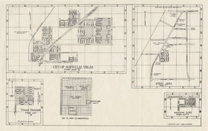
Street map of the city of Las Vegas & vicinity, showing streets, main roads and recreation areas, 1954
Date
1954
Description
7 maps on 3 sheets, 2 leaves ; 21 x 31 cm. or smaller on sheets 22 x 35 cm. folded to 22 x 13 cm. in paper cover. Title from cover. Copyright held by James E. Stringer. 1st ed. Includes maps of North Las Vegas, the Strip and Vegas Heights and Meadow Acres. Includes key to map coordinates. Includes index. "Map of Las Vegas & Vicinity showing streets, main roads, and recreation areas." Original publisher: R.W. Baldwin.
Image

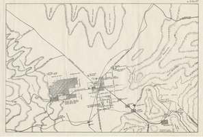

Surficial geologic map of the Specter Range NW quadrangle, Nye County, Nevada, 1989
Date
1989
Description
58 x 47 cm., on sheet 74 x 81 cm., folded in envelope 30 x 24 cm. Relief shown by contours and spot heights. "Geology mapped in 1984-85." Includes text, bibliography, and location maps. "Prepared in cooperation with the U. S. Deparment of Energy." "Base from U. S. Geological Survey, 1961. Photorevised 1983. 10,0000-foot grid ticks based on Nevada coordinate system, central zone. 1000-meter Universal Transverse Mercator grid ticks, zone 11, shown in blue." Original publisher: U. S. Geological Survey, Series: Miscellaneous investigations series map I, Scale: 1:24 000.
Image

Geologic map of the northeast quarter of the Bullfrog 15-minute quadrangle, Nye County, Nevada, 1990
Date
1990
Description
58 x 46 cm., on sheet 87 x 102 cm., folded in envelope 30 x 24 cm. Relief shown by contours and spot heights. "Contour interval 40 feet." "Base from U.S. Geological Survey 1:62,500. 1954." "Geology mapped in 1985 and 1988." Includes text, bibliography, 4 col. cross sections, and location and index maps. "Prepared in cooperation with the U. S. Atomic Commission." Original publisher: U. S. Geological Survey, Series: Miscellaneous investigations series, map I, Scale: 1:24 000.
Image

Geologic map of the Plutonium Valley quadrangle, Nye and Lincoln counties, Nevada, 1965
Date
1965
Description
58 x 46 cm., on sheet 77 x 83 cm., folded in envelope 30 x 24 cm. Relief shown by contours and spot heights. "Geology mapped in 1961." Includes description of map units, col. cross section, and quadrangle location map. "Prepared in cooperation with the U. S. Atomic Commission." Original publisher: Interior, Geological Survey, Series: Geologic quadrangle map GQ, Scale: 1:24 000.
Image