Search the Special Collections and Archives Portal
Search Results
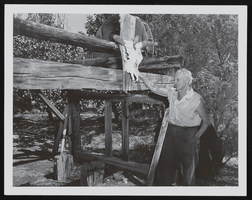
Photograph of Pop Buol and oxen stall, Pahrump (Nev.), 1950s
Date
1950 to 1959
Archival Collection
Description
Frank "Pop" Buol stands next to a stall with an animal skull hanging at the top. Inscription with photograph reads: "Stall was to secure oxen to shoe them hauling charcoal from Wheeler Canyon kilns (still there) to Death Valley;[Pahrump]" See image 0131 098 pho023474.
Image
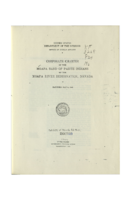
Corporate Charter of the Moapa Band of Paiute Indians of the Moapa River Reservation, Nevada
Date
1942-04-17
Archival Collection
Description
Charter of incorporation of the Moapa Band of Paiute Indians of the Moapa River Reservation, Nevada under the June 18, 1934 Wheeler-Howard Act (Indian Reorganization Act). The charter encompases eleven (11) sections: Corporate Existence, Perpetual Succession, Membership, Management, Corporate Powers, Termination of Supervisory Powers, Corporate Property, Corporate Dividends, Corporate Accounts, Amendments, and Ratification.
Text
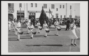
Boulder City Parade: photographic print
Date
1934
Archival Collection
Description
From the Tom and Erma Godbey Photograph Collection (PH-00262) -- Written on the back of the photograph, "1934 First Boulder City parade that the Drum & Bugle Corps were in. L-R: Front Row Ray Wiggins, Freddie Miller, Tommy Godbey, Jack Wheeler; Second Row Bonnie Buck, Norma Smiley, Freddie Abercrombie; Third Row (?), Ralph Hornsworth."
Image
Pagination
Refine my results
Content Type
Creator or Contributor
Subject
Archival Collection
Digital Project
Resource Type
Year
Material Type
Place
Language
Records Classification

