Search the Special Collections and Archives Portal
Search Results
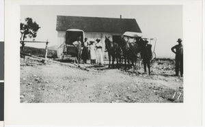
Photograph of people in front of school house, Lincoln County (Nev.), 1890-1910
Date
1890 to 1910
Archival Collection
Description
Unidentified people stand in front of a school house on Wheeler Ranch, Highland Range.
Image
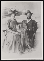
May Bradford's parents: photographic print
Date
1906
Archival Collection
Description
May Bradford's parents in 1906, Sallie Jane Leona (Ward) (Wheeler) Bradford and Seymour Kimball Bradford.
Image

View of Mount Charleston's Peak, Nevada: photographic print
Date
1910 (year approximate) to 1930 (year approximate)
Archival Collection
Description
From the Chester R. Longwell Photograph Collection (PH-00311). Photograph taken from Wheeler's Wash.
Image
Pagination
Refine my results
Content Type
Creator or Contributor
Subject
Archival Collection
Digital Project
Resource Type
Year
Material Type
Place
Language
Records Classification


