Search Results
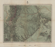
Map of economic features of parts of southern Colorado and northern New Mexico Atlas sheet no. 70(A.), May 5, 1877
Date
1877-05-07
Description
37 x 49 cm. Relief shown by hachures and spot heights. Prime meridians: Greenwich and Washington, D.C. "Atlas sheet no. 70(A)." "Issued May 7th, 1877." "Expeditions of 1874, 1875 & 1876 under the command of 1st. Lieut. Geo. M. Wheeler, Corps of Engineer, U.S. Army." "Weyss, Herman & Mahlo, del." "By order of the honorable the Secretary of War." "Under the direction of Brig. General A. A. Hunphreys, Chief of Engineers, U. S. Army." Original publisher: U.S. Geographical Surveys West of the 100th Meridian, Scale: 1 inch to 4 miles or 1: 253440.
Image

Map showing detailed topography of the country traversed by the reconnaissance expedition through southern & southeastern Nevada, 1869 (reproduction)
Date
1869
Description
At top of map: 'Reconnaissance Maps, Department of California.' 'In charge of, Lieut. Geo. M. Wheeler, U.S. Engineers; assisted by Lieut. D.W. Lockwood, Corps of Engineers,U.S.A., 1969.' 'P.W. Hamel, chief topographer and draugthsman.' 'Traced 11-13-67.' 'BGS'; the G is enclosed in an arrowhead shape. 'Officially compiled and published at the Engineer Office, Head Quarters Department of California in 1869 and 70 by order of Brigadier General E.O.C. Ord. Comm'dg. [signed] Geo. M. Wheeler, Lieutenant of Engineers In Charge, Head Quarters Dept. of Cal. Oct. 26th, 1870.' Includes information from railroad maps, the United States Geological Survey of the 40th parallel and from Lieutenant Ives' explorations along the Colorado. Map includes camps, astronomical stations, good and bad wagon roads, trails, springs, settlements, mining districts, state and county boundaries and the watershed between the Humboldt and Colorado Basin. Shows most of eastern half of Nevada. Relief shown by hachures and spot heights. Scale indeterminable. (W 117°00´--W 113°00´/N 41°45´--N 35°45´). Series: Reconnaissance maps. Military map / Department of California
no. 1. Reproduction. Map is printed in purple. Scale of original map: [1:760,320]. 1 in. to approx. 12 miles. Includes dots hand-colored with red pencil marking Indian rancherias.
no. 1. Reproduction. Map is printed in purple. Scale of original map: [1:760,320]. 1 in. to approx. 12 miles. Includes dots hand-colored with red pencil marking Indian rancherias.
Image
Sahara Pavilion Shopping Center, 1989 September 06; 1991 January 22
Level of Description
File
Scope and Contents
This set includes: site plans, landscape plan, exterior elevations, topographic surveys and redlining.
This set includes drawings for Allied Development Corp. (client) by Shepherd, Nelson and Wheeler (engineer).
Archival Collection
Gary Guy Wilson Architectural Drawings
To request this item in person:
Collection Number: MS-00439
Collection Name: Gary Guy Wilson Architectural Drawings
Box/Folder: Roll 454
Collection Name: Gary Guy Wilson Architectural Drawings
Box/Folder: Roll 454
Archival Component
The Sports Authority: Tenant Improvement, 1990 April 16; 1990 June 18
Level of Description
File
Scope and Contents
This set include: floor plans, reflected ceiling plans, redlining, interior elevations, finish/door/window schedules and index sheet.
This set includes drawings for the Sports Authority (client) by Shepherd, Nelson and Wheeler (engineer).
Archival Collection
Gary Guy Wilson Architectural Drawings
To request this item in person:
Collection Number: MS-00439
Collection Name: Gary Guy Wilson Architectural Drawings
Box/Folder: Roll 553
Collection Name: Gary Guy Wilson Architectural Drawings
Box/Folder: Roll 553
Archival Component

Map showing detailed topography of the country traversed by the reconnaissance expedition through southern & southeastern Nevada, 1869
Date
1869
Description
At top of map: 'Reconnaissance Maps, Department of California.' In lower right corner: 'Photolith. by the N.Y. Lithg. Engrg. & Prtg. Co.' 'In charge of, Lieut. Geo. M. Wheeler, U.S. Engineers; assisted by Lieut. D.W. Lockwood, Corps of Engineers,U.S.A., 1969.' 'P.W. Hamel, chief topographer and draugthsman.' 'Officially compiled and published at the Engineer Office, Head Quarters Department of California in 1869 and 70 by order of Brigadier General E.O.C. Ord. Comm'dg. [signed] Geo. M. Wheeler, Lieutenant of Engineers In Charge, Head Quarters Dept. of Cal. Oct. 26th, 1870.' Includes information from railroad maps, the United States Geological Survey of the 40th parallel and from Lieutenant Ives' explorations along the Colorado. Map includes camps, astronomical stations, good and bad wagon roads, trails, springs, settlements, mining districts, state and county boundaries and the watershed between the Humboldt and Colorado Basin. Shows most of eastern half of Nevada. Relief shown by hachures and spot heights. Scale: [1:760,320]. 1 in. to approx. 12 miles. (W 117°00´--W 113°00´/N 41°45´--N 35°45´). Series: Reconnaissance maps. Military map / Department of California
no. 1.miles. Library's copy has counties hand-outlined in colored markers.
no. 1.miles. Library's copy has counties hand-outlined in colored markers.
Image

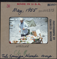
Photographic slide of a person at Tule Springs, Nevada, May 1955
Date
1955-05
Archival Collection
Description
An unidentified person standing next to a table with food on it. Written on the slide: "Wheeler. Ch R. Tule Springs, Nevada camp."
Image