Search Results
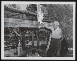
Photograph of Pop Buol and oxen stall, Pahrump (Nev.), 1950s
Date
1950 to 1959
Archival Collection
Description
Frank "Pop" Buol stands next to a stall with an animal skull hanging at the top. Inscription with photograph reads: "Stall was to secure oxen to shoe them hauling charcoal from Wheeler Canyon kilns (still there) to Death Valley;[Pahrump]" See image 0131 098 pho023474.
Image
Corporate Charter of the Moapa Band of Paiute Indians of the Moapa River Reservation, Nevada
Date
1942-04-17
Archival Collection
Description
Charter of incorporation of the Moapa Band of Paiute Indians of the Moapa River Reservation, Nevada under the June 18, 1934 Wheeler-Howard Act (Indian Reorganization Act). The charter encompases eleven (11) sections: Corporate Existence, Perpetual Succession, Membership, Management, Corporate Powers, Termination of Supervisory Powers, Corporate Property, Corporate Dividends, Corporate Accounts, Amendments, and Ratification.
Text
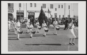
Boulder City Parade: photographic print
Date
1934
Archival Collection
Description
From the Tom and Erma Godbey Photograph Collection (PH-00262) -- Written on the back of the photograph, "1934 First Boulder City parade that the Drum & Bugle Corps were in. L-R: Front Row Ray Wiggins, Freddie Miller, Tommy Godbey, Jack Wheeler; Second Row Bonnie Buck, Norma Smiley, Freddie Abercrombie; Third Row (?), Ralph Hornsworth."
Image