Search Results
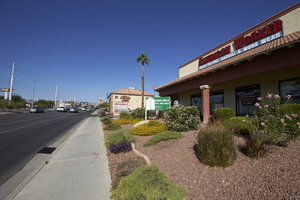
Traffic and businesses on West Sahara Avenue east of Torrey Pines Drive, looking west, Las Vegas, Nevada: digital photograph
Date
2017-09-20
Archival Collection
Description
Traffic flows in front of commercial development along West Sahara Avenue east of Torrey Pines Drive.
Image

Bus stop on West Sahara Avenue at South Valley View Boulevard looking west, Las Vegas, Nevada: digital photograph
Date
2017-09-06
Archival Collection
Description
An RTC Sahara Express bus stop on West Sahara Avenue near South Valley View Boulevard.
Image
Great American Plaza West Sahara Avenue west of South Durango Drive, Las Vegas, Nevada: digital photograph
Date
2017-08-29
Archival Collection
Description
Entrance to the Great American Plaza on West Sahara Avenue east of South Durango Drive. August 29, 2017 UNLV Libraries Special Collections / Aaron Mayes N36 °08.649' x W115 °16.403')
Image
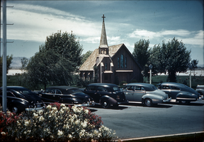
Slide of the parking lot of the Little Church of the West, Las Vegas, circa 1940s
Date
1940 to 1949
Archival Collection
Description
A color slide of the wedding chapel, the Little Church of the West, and the parking lot filled with cars.
Image
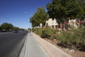
Landscaping along East Sahara Avenue west of Tree Line Drive, looking west, Las Vegas, Nevada: digital photograph
Date
2017-09-28
Archival Collection
Description
Landscaping next to East Sahara Avenue west of Tree Line Drive in front of the Villas at Sunrise Mountain Apartments.
Image
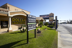
Dollar Loan Center and other businesses on West Sahara Avenue west of Jones Boulevard, looking east, Las Vegas, Nevada: digital photograph
Date
2017-09-20
Archival Collection
Description
Commercial development along West Sahara Avenue west of Jones Boulevard.
Image
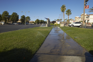
Grass watering along West Sahara Avenue at Fort Apache Road, looking west, Las Vegas, Nevada: digital photograph
Date
2017-10-10
Archival Collection
Description
Sprinklers irrigate grass at the Village Square commercial center on the northwest corner of West Sahara Avenue and Fort Apache Road.
Image
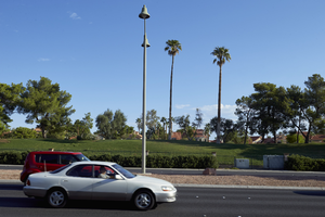
Canyon Gate Country Club on West Sahara Avenue west of South Durango Drive, Las Vegas, Nevada: digital photograph
Date
2017-08-29
Archival Collection
Description
Traffic flows down West Sahara Avenue past the Canyon Gate Country Club near South Durango Drive.
Image

Map showing parts of eastern and southeastern Nevada and southwestern Utah, circa 1873
Date
1869
1872 to 1873
Archival Collection
Description
Scale 1:506,880. 1 in. to 8 miles (W 117°30--W 114°45/N 37°20--N 40°00). Relief shown by hachures and spot heights. At top left: 'Explorations & surveys west of the one-hundredth meridian.' At top right: 'Parts of Eastern & Southeastern Nevada & Southwestern Utah. Atlas sheet number 66.' At bottom left: 'Expeditions of 1869, 1872 & 1873.' At bottom right: ' 1st Lieut. Geo. M. Wheeler, Corps of Engineers, com'd'g.' Seal of the War Department, Corps of Engineers, U.S. Army at top center of map. Originally published as part of the geological atlas which is an appendix to the Survey's Report upon United States geographical surveys west of the one hundredth meridian, published in 1876?
Image