Search Results
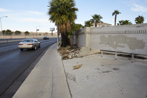
Flood control feature of single family housing development on East Sahara Avenue west of Lamb Boulevard, looking west, Las Vegas, Nevada: digital photograph
Date
Archival Collection
Description
Image
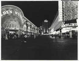
Photograph of Fremont Street looking west (Las Vegas), 1991
Date
Archival Collection
Description
Looking West Down Fremont Street in 1991. Signature on back of photo: "S Vinci for '91."
Site Name: Fremont Street
Address: Fremont street, Las Vegas, NV
Image
KNPR "Las Vegas: Mississippi of the West or Promised Land?" radio documentary
Identifier
Abstract
Nevada Public Radio (KNPR) radio documentary entitled ""Las Vegas: Mississippi of the West or Promised Land?" hosted by William J. Drummond and Faith Fancher that aired on June 24, 1991. In this two-part series, the hosts and a variety of guests discuss racial segregation in Las Vegas, Nevada's past and the racial climate of the city in 1991. Guests include, but are not limited to, Peter Lyn Hayes, Joe Williams, Roosevelt Fitzgerald, Eugene Moehring, James West, Eric Cooper, Sarah Knight Preddy, and Frank Hawkins.
Archival Collection
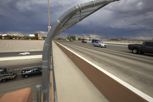
Traffic on West Sahara Avenue, Las Vegas, Nevada: digital photograph
Date
Archival Collection
Description
Image
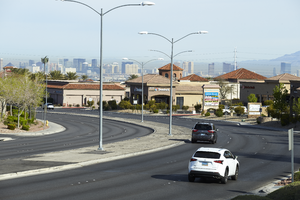
Eastern Avenue curves north-west with the Las Vegas skyline in the background, looking north-west in Henderson, Nevada: digital photograph
Date
Archival Collection
Description
From the UNLV University Libraries Photographs of the Development of the Las Vegas Valley, Nevada (PH-00394). Part of the collection documents the entire 19 mile length of the north/south Eastern Avenue / Civic Center Drive alignment. This photograph was captured in the section of Eastern Avenue between Coronado Center Drive and Sunridge Heights Parkway.
Image
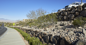
A pathway along Sun City Anthem Drive west of Eastern Avenue, looking west-northwest in Henderson, Nevada: digital photograph
Date
Archival Collection
Description
From the UNLV University Libraries Photographs of the Development of the Las Vegas Valley, Nevada (PH-00394). Part of the collection documents the entire 19 mile length of the north/south Eastern Avenue / Civic Center Drive alignment. This photograph was captured in the section of Eastern Avenue between Grand Hills and Sun City Anthem Drives.
Image
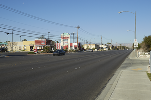
A commercial center along Sunset Road west of Eastern Avenue, looking west-southwest in Las Vegas, Nevada: digital photograph
Date
Archival Collection
Description
From the UNLV University Libraries Photographs of the Development of the Las Vegas Valley, Nevada (PH-00394). Part of the collection documents the entire 19 mile length of the north/south Eastern Avenue / Civic Center Drive alignment. This photograph was captured in the section of Eastern Avenue between Sunset and Warm Springs Roads.
Image
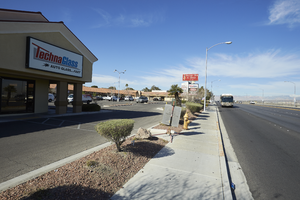
Businesses in a commercial center on Windmill Lane west of Eastern Avenue, looking west-southwest in Las Vegas, Nevada: digital photograph
Date
Archival Collection
Description
From the UNLV University Libraries Photographs of the Development of the Las Vegas Valley, Nevada (PH-00394). Part of the collection documents the entire 19 mile length of the north/south Eastern Avenue / Civic Center Drive alignment. This photograph was captured in the section of Eastern Avenue between Warm Springs Road and Windmill Parkway.
Image
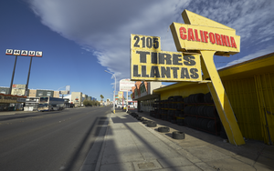
Signage for a tire shop on Fremont Street west of Eastern Avenue, looking west-northwest in Las Vegas, Nevada: digital photograph
Date
Archival Collection
Description
From the UNLV University Libraries Photographs of the Development of the Las Vegas Valley, Nevada (PH-00394). Part of the collection documents the entire 19 mile length of the north/south Eastern Avenue / Civic Center Drive alignment. This photograph was captured in the section of Eastern Avenue between Stewart Avenue and Charleston Boulevard.
Image
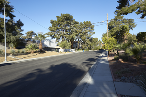
Looking west up Pueblo Way in the Paradise Palms neighborhood west of Eastern Avenue in Las Vegas, Nevada: digital photograph
Date
Archival Collection
Description
From the UNLV University Libraries Photographs of the Development of the Las Vegas Valley, Nevada (PH-00394). Part of the collection documents the entire 19 mile length of the north/south Eastern Avenue / Civic Center Drive alignment. This photograph was captured in the section of Eastern Avenue between Desert Inn and Flamingo Roads.
Image