Search Results
Urban Storm Water Runoff and Ground-Water Quality, EPA #90-2304, 1991 January
Level of Description
File
Archival Collection
Yucca Mountain Site Characterization Office Collection
To request this item in person:
Collection Number: MS-00091
Collection Name: Yucca Mountain Site Characterization Office Collection
Box/Folder: Box 46
Collection Name: Yucca Mountain Site Characterization Office Collection
Box/Folder: Box 46
Archival Component
Sale of Las Vegas Land and Water Company To Water District, File number 1, 1952-1954
Level of Description
File
Archival Collection
Union Pacific Railroad Collection
To request this item in person:
Collection Number: MS-00397
Collection Name: Union Pacific Railroad Collection
Box/Folder: Box 14
Collection Name: Union Pacific Railroad Collection
Box/Folder: Box 14
Archival Component
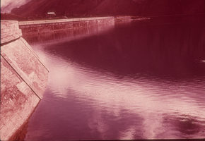
Panoramic view of a body of water: photographic slide
Date
1977 to 1991
Archival Collection
Description
From the Sister Klaryta Antoszewska Photograph Collection (PH-00352)
Image
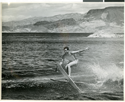
Photograph of a man water skiing, Lake Mead, late 1940s
Date
1945 to 1949
Archival Collection
Description
An unidentified man water-skiing on Lake Mead. He is holding on to the handle with one hand.
Image
Division of Water Resources; Las vegas Valley Water Usage Report by Coache, Robert, 1988
Level of Description
File
Archival Collection
Clark County Planning Commission Research Library Collection
To request this item in person:
Collection Number: MS-01027
Collection Name: Clark County Planning Commission Research Library Collection
Box/Folder: Box 19
Collection Name: Clark County Planning Commission Research Library Collection
Box/Folder: Box 19
Archival Component
Water Resources Center; An Overview by Water Resources Center - Desert Research Institute, 1995 February
Level of Description
File
Archival Collection
Clark County Planning Commission Research Library Collection
To request this item in person:
Collection Number: MS-01027
Collection Name: Clark County Planning Commission Research Library Collection
Box/Folder: Box 14
Collection Name: Clark County Planning Commission Research Library Collection
Box/Folder: Box 14
Archival Component
Water flowing from a broken water line, Las Vegas, Nevada, 2017 August 29
Level of Description
File
Archival Collection
UNLV University Libraries Photographs of the Development of the Las Vegas Valley, Nevada
To request this item in person:
Collection Number: PH-00394
Collection Name: UNLV University Libraries Photographs of the Development of the Las Vegas Valley, Nevada
Box/Folder: N/A
Collection Name: UNLV University Libraries Photographs of the Development of the Las Vegas Valley, Nevada
Box/Folder: N/A
Archival Component
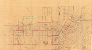
Map of Las Vegas showing areas owned by the Union Pacific Railroad Company, water pipes and other water utilities, circa 1942
Date
1938 to 1946
Archival Collection
Description
Map showing downtown Las Vegas and tracts to the west showing water supply lines, wells, springs, and settling basins. Various areas outlined in red and yellow. Scale [ca. 1:7,200] 1 in.=600 feet. Cadastral map. Blueline print. Areas owned by railroad outlined by hand in different colored markers. Library's copy includes hand-written calculations.
Image
Reports - Annual State Labor Commission, Water and Electric Light Utilities (1 of 2)
Date
1913 to 1946
Archival Collection
Description
Series 2. Las Vegas Land and Water Company -- Walter Bracken and the Las Vegas, Nevada Office -- Water Company
Text
Water Pollution: Water Pipe Line From Rye Patch. Contains correspondence, 1959 December
Level of Description
File
Archival Collection
Howard Cannon Papers
To request this item in person:
Collection Number: MS-00002
Collection Name: Howard Cannon Papers
Box/Folder: Box 11 (86th Session)
Collection Name: Howard Cannon Papers
Box/Folder: Box 11 (86th Session)
Archival Component