Search Results
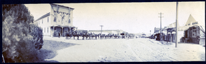
Photograph of packtrain on Main Street, Tonopah (Nev.), early 1900s
Date
Unknown year in the decade of the 1900s
Archival Collection
Description
Photograph of packtrain on Main Street, Tonopah (Nev.), early 1900s
Image


Studebaker Corporation
Taken from Wiki Page: "Studebaker (1852–1967)) was an American wagon and automobile manufacturer based in South Bend, Indiana. Founded in 1852 and incorporated in 1868 under the name of the Studebaker Brothers Manufacturing Company, the company was originally a producer of wagons for farmers, miners, and the military.
Corporate Body
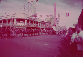
Film transparency of the Helldorado Parade near the Overland Hotel and Las Vegas Club on Fremont Street (Las Vegas), circa 1950s
Date
1950 to 1959
Archival Collection
Description
The Helldorado Parade in front of the Overland Hotel on Main and Fremont and the Las Vegas Club. Helldorado is an annual parade that celebrates Las Vegas' western history.
Site Name: Fremont Street
Address: Fremont street, Las Vegas, NV
Image
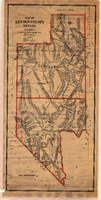
Map of Lincoln County (Nev.), 1908
Date
1908
Description
Scale [ca. 1:380,160]. 1 in. to approx. 6 miles (W 116 --W 114 /N 39 --N 35 ) ; 1 map : hand col., mounted on linen ; 115 x 54 cm ; Relief shown by hachures and spot heights ; Hand colored ; Shows range and township grid ; Shows towns, railroads, proposed railroads, wagon roads and springs ;
Image
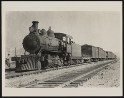
Midway Ore Station at Tonopah and Tidewater: photograph
Date
1907
Archival Collection
Description
Tonopah & Tidewater, Midway Ore Station, 1907. The railroad ran from E California to SW Nevada. Inscription reads "Meeting final 20 mule team wagons." The stamp on the back of the photo says: "Mallory Hope Ferrell P. O. Box 2837 Peachtree City, GA 30269."
Image
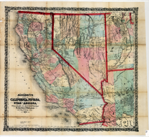
Bancroft's map of California, Nevada, Utah and Arizona, 1873
Date
1873
Description
Hand colored ; Relief shown by hachures and spot heights ; Prime meridian: Washington, D.C ; Shows railroads, proposed railroads and wagon roads, etc. Published by A.L. Bancroft & Company. Scale [ca. 1:1,520,640]. 1 in. to 24 miles (W 124°--W 111°/N 42°--N 32°).
Image