Search Results
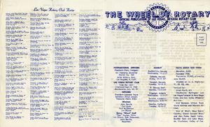
The Wheel of Rotary Las Vegas Rotary Club newsletter, February 9, 1950
Date
Archival Collection
Description
Text
Valorie J. Vega oral history interview
Identifier
Abstract
Oral history interview with Valorie J. Vega conducted by Laurents Bañuelos-Benitez on November 19, 2018 for the Latinx Voices of Southern Nevada Oral History Project. In this interview, Vega discusses her upbringing in Van Nuys, California. She describes her father’s employment with the Los Angeles County Fire Department, her attendance at California State University, Northridge, and majoring in Spanish with a minor in Chicano studies. Vega recalls entering a master’s program for Spanish interpretation, moving to Las Vegas, Nevada in 1978, and becoming a supervisor for court interpreters. Later, Vega talks about enrolling in law school at the University of Southern California (USC), working as a Clark County deputy attorney, and later becoming a judge. Lastly, Vega discusses her experience being a female Hispanic judge, and her involvement with the Huellas Program at the University of Nevada, Las Vegas (UNLV).
Archival Collection
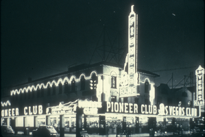
Slide of the Pioneer Club and Las Vegas Club, Las Vegas, circa 1930s
Date
Archival Collection
Description
Image
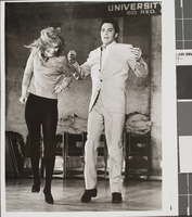
Photograph of "Viva Las Vegas" dance sequence, Las Vegas, 1963
Date
Archival Collection
Description
Image
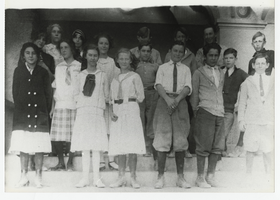
Photograph of students on the steps of the Las Vegas High School, Las Vegas (Nev.), 1900-1925
Date
Archival Collection
Description
Site Name: Las Vegas High School (Las Vegas, Nev.)
Image
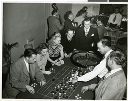
Photograph of the Las Vegas Strip Hotel Gamblers, Las Vegas, circa 1940s
Date
Archival Collection
Description
Image
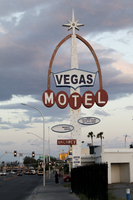
Photographs of Vegas Motel sign, Las Vegas (Nev.), March 3, 2017
Date
Archival Collection
Description
Site address: 2212 Fremont St
Sign details: This motel was not found on the Assessor's page so there was not a record found on when the building was constructed. In between April of 2014 and May of 2015 the building was demolished though the signs still remain.
Sign condition: 3- Paint is still relatively nice on the sign but now there are just remains of lightbulbs/neon tubing.
Sign form: Pylon and a roadside directional sign
Sign-specific description: The main pylon is a rectangular beam with light blue paint at the bottom and white on top that has incandescent light bulbs. In the middle of the sign there are horizontal MOTEL white block font letters with each letter in an individual red circle as well as the letters outlined in skeletal neon. There is a red arch coming out of the letter M and ending over the letter L, and this arch goes to the top of the sign. Above the letters is a blue curvilinear sign box with a plastic back lit sign that has blue letters stating VEGAS. On the top of the sign is a white star burst. There also is a smaller roadside directional sign to the west of the main sign that has a white board painted with red letters stating Vegas Motel there is a big curved red arrow also on this one pointing to where they would have entered the driveway.
Sign - type of display: Neon, incandescent light bulbs and plastic back lit sign
Sign - media: Steel and plastic
Sign - non-neon treatments: Plastic back lit sign and incandescent light bulbs
Sign animation: Possibly once had a flasher for the incandescent light bulbs, but can not be determined because there are just remains of the light bulbs currently.
Sign environment: This location was on East Fremont near Eastern Ave where many other motels used to stand, but many have been demolished. Many of the signs of these motels though are still up on though they are not all in working condition.
Sign - thematic influences: This sign has remnants of Googie styles with the star as well as the arch portion of the sign.
Sign - artistic significance: The starburst on top is very similar to the star on Betty Willis Welcome to Fabulous Las Vegas sign.
Survey - research locations: Google map satellite and roadside view. Attempted assessor's page, UNLV special collections and Stephanie Roadside, as well as Vintage Las Vegas but no records found.
Survey - research notes: This location was very difficult to research since the building is no longer there as well as that if you search Vegas Motel into a database to research nearly every motel in Vegas shows up, but also nothing was found for this one.
Surveyor: Emily Fellmer
Survey - date completed: 2017-09-29
Sign keywords: Pylon; Neon; Incandescent; Steel; Plastic; Backlit; Flashing; Roadside; Pole sign
Mixed Content
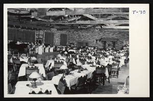
Postcard of El Rancho Vegas, Las Vegas, circa 1941-1960
Date
Archival Collection
Description
Image
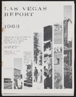
Las Vegas Report
Date
Archival Collection
Description
Series XVII. Hotel and Casino Promotional Events
Mixed Content
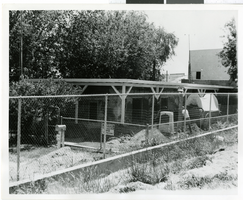
Photograph of Old Las Vegas Mormon Fort, Las Vegas (Nev.), 1974
Date
Archival Collection
Description
Image