Search the Special Collections and Archives Portal
Search Results
Slide: Tonopah Hall dormitory, University of Nevada, Las Vegas, 1984
Level of Description
File
Archival Collection
University of Nevada, Las Vegas Photograph Collection
To request this item in person:
Collection Number: PH-00062
Collection Name: University of Nevada, Las Vegas Photograph Collection
Box/Folder: Binder PB-002
Collection Name: University of Nevada, Las Vegas Photograph Collection
Box/Folder: Binder PB-002
Archival Component
Album 3: Goldfield and Tonopah, Nevada: photograph album, approximately 1900-1915
Level of Description
Item
Archival Collection
C. A. Earle Rinker Photograph Collection of Goldfield, Nevada
To request this item in person:
Collection Number: PH-00350
Collection Name: C. A. Earle Rinker Photograph Collection of Goldfield, Nevada
Box/Folder: Oversized Box 08
Collection Name: C. A. Earle Rinker Photograph Collection of Goldfield, Nevada
Box/Folder: Oversized Box 08
Archival Component

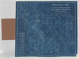
Prospectors map of Tonopah, Goldfield, Bull Frog, & principal mining districts
Date
1905
Description
Showing towns, roads, trails & watering places, in southern Nevada & Death Valley region, California. 1 map ; 44 x 49 cm, folded in cover 18 x 11 cm. Scale [1:950,400]. 15 mi. to an inch. (W 119⁰--W 114⁰/N 39⁰--36⁰). Relief shown by hachures. Blueprint. "Jan. 1905." Includes list of distances. Goldfield, Nev. : Booker, Philbrick & Fenner.
Image
Bar and brothel belonging to Bobby Duncan located in Tonopah, 1950-1953
Level of Description
File
Archival Collection
Nye County, Nevada Photograph Collection
To request this item in person:
Collection Number: PH-00221
Collection Name: Nye County, Nevada Photograph Collection
Box/Folder: Folder 28
Collection Name: Nye County, Nevada Photograph Collection
Box/Folder: Folder 28
Archival Component
Department of Defense. Tonopah Test Range. Contains correspondence, 1981 August
Level of Description
File
Archival Collection
Howard Cannon Papers
To request this item in person:
Collection Number: MS-00002
Collection Name: Howard Cannon Papers
Box/Folder: Box 12 (97th Session)
Collection Name: Howard Cannon Papers
Box/Folder: Box 12 (97th Session)
Archival Component

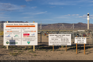
Project information signs at the entrance to Crescent Dunes Solar, near Tonopah, Nevada: digital photograph
Date
2014-06-24
Archival Collection
Description
Photographer's note: "Project information signs at the entrance to Crescent Dunes Solar, near Tonopah, Nevada, USA."
Photographer's assigned keywords: "110 megawatts; CSP; Concentrated Solar Energy; Concentrated Solar Power; Crescent Dunes; NV; Nevada; Solar Reserve; SolarReserve; Tonopah; concentrated solar thermal; green energy; ground-based photo; molten salt; on-site; renewable energy; storage; tower."
Photographer's assigned keywords: "110 megawatts; CSP; Concentrated Solar Energy; Concentrated Solar Power; Crescent Dunes; NV; Nevada; Solar Reserve; SolarReserve; Tonopah; concentrated solar thermal; green energy; ground-based photo; molten salt; on-site; renewable energy; storage; tower."
Image

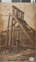
Photograph of a man standing on a mining headframe, Gold Reef Mining Company, Tonopah, Nevada, July 7, 1918
Date
1918-07-07
Archival Collection
Description
A man standing on a headframe at the Gold Reef Mining Company in Tonopah, Nevada.
Image
Stage in front of Lathrop & Davis General Merchandise, Tonopah, approximately 1901-1905
Level of Description
File
Archival Collection
Tonopah-Goldfield Mining Photograph Collection
To request this item in person:
Collection Number: PH-00023
Collection Name: Tonopah-Goldfield Mining Photograph Collection
Box/Folder: Oversized Box 01
Collection Name: Tonopah-Goldfield Mining Photograph Collection
Box/Folder: Oversized Box 01
Archival Component
Double handed drilling contest, Tonopah Railroad Carnival, 1904 July 26
Level of Description
File
Archival Collection
Tonopah-Goldfield Mining Photograph Collection
To request this item in person:
Collection Number: PH-00023
Collection Name: Tonopah-Goldfield Mining Photograph Collection
Box/Folder: Oversized Box 01
Collection Name: Tonopah-Goldfield Mining Photograph Collection
Box/Folder: Oversized Box 01
Archival Component
Pagination
Refine my results
Content Type
Creator or Contributor
Subject
Archival Collection
Digital Project
Resource Type
Year
Material Type
Place
Language
Records Classification
