Search Results
Architectural drawings of residential home in Las Vegas, Nevada, exterior elevations, 1955
Date
Archival Collection
Description
Front, rear, left and right exterior elevations of a ranch-style residential home in the Greater Las Vegas development in Las Vegas, Nevada.
Site Name: Greater Las Vegas
Image
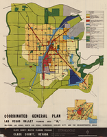
Map showing coordinated general plan for Las Vegas Valley, Planning Area A5, circa 1965-1968
Date
Description
Text

Blueprint showing proposed pipeline for gravity water supply at Las Vegas, Nevada, February 16, 1905
Date
Description
Image
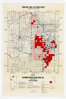
Map showing home-site lands in the Las Vegas Valley, 1955
Date
Description
Image
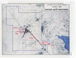
Map showing improvements made to the Las Vegas Valley Water District and vicinity, circa 1950
Date
Description
Image
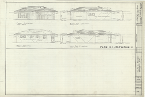
Architectural drawings of residential home in Las Vegas, Nevada, exterior elevations, 1955
Date
Archival Collection
Description
Two different sets of drawings of front, rear, left and right exterior elevations of a ranch-style residential home in the Greater Las Vegas development in Las Vegas, Nevada.
Site Name: Greater Las Vegas
Image

Plat of H.F.M & M addition to city of Las Vegas, Clark County, Nevada, comprising the west 1/2 of N.W. 1/4 Sec. 27, Twp. 20 S., R. 61 E., M.D.B & M, March 8, 1924
Date
Description
Image

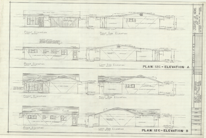
Architectural drawings of residential home in Las Vegas, Nevada, exterior elevations, 1955
Date
Archival Collection
Description
Two different sets of drawings of front, rear, left and right exterior elevations of a ranch-style residential home in the Greater Las Vegas development in Las Vegas, Nevada.
Site Name: Greater Las Vegas
Image

Blueprint map showing proposed water pipeline from Big Spring to Las Vegas, Nevada, January 24, 1911
Date
Archival Collection
Description
Image

Architectural drawing of additions and alterations to the mens' and womens' health clubs in the Sands Hotel, Las Vegas, Nevada, April 19, 1965
Date
Description
Floor plans, sections, elevations for mens' and womens' health clubs at the Sands Hotel, Las Vegas, Nevada. Includes door and finish schedules. "Sheet no. 17A. Job no. 420. Drawn by Shoji Yasuda. Job captain, Mas Tokubo. 2-26-65. Revised 4-19-65."
Site Name: Sands Hotel
Address: 3355 Las Vegas Boulevard South;
Image