Search Results
Las Vegas NW quadrangle
Date
Description
'Prepared by the U.S. Department of the Interior, Geological Survey, in cooperation with the U.S. Department of Housing and Urban Development, Federal Insurance Administration. 1973.'
Image
Las Vegas SE quadrangle
Date
Description
Image

Las Vegas SW quadrangle
Date
Description
'Prepared by the U.S. Department of the Interior, Geological Survey, in cooperation with the U.S. Department of Housing and Urban Development, Federal Insurance Administration. 1973.'
Image

Redevelopment plan map for downtown Las Vegas, Nevada, November 18, 1987
Date
Description
Image

Plat showing original townsite and subdivisions, Las Vegas, Lincoln County, Nevada, May 1905
Date
Description
Land owned by the San Pedro, Los Angeles & Salt Lake Railroad is outlined. Scale: [ca. 1:12,000]. 1 inch = 1,000 feet. Cadastral map. Blueline print. Additional copy available in the J.T. McWilliams manuscript collection
Image

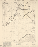
Map of the Las Vegas Strip, May 1950
Date
Description
Image

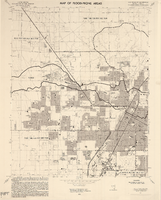
Map of Las Vegas Valley showing artesian wells, circa 1920
Date
Description
Image
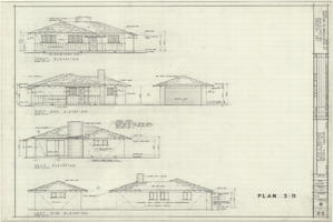
Architectural drawings of residential home in Las Vegas, Nevada, exterior elevations, May 23, 1958
Date
Archival Collection
Description
Front, right, rear and left exterior elevations of a ranch-style residential home and detached garage in the Las Verdes Heights development in Las Vegas, Nevada. "Drawn by J.C.M. & P.J.C. Checked by E.C.B." "Sheet no. 8 of 25."
Site Name: Las Verdes Heights
Image
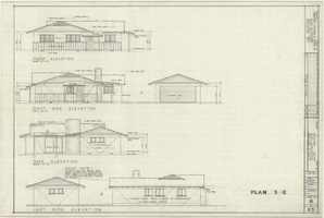
Architectural drawings of residential home in Las Vegas, Nevada, exterior elevations, May 23, 1958
Date
Archival Collection
Description
Front, right, rear and left exterior elevations of a ranch-style residential home with detached garage in the Las Verdes Heights development in Las Vegas, Nevada. "Drawn by P.J.C. & J.C.M. Checked by E.C.B." "Sheet no. 9 of 25."
Site Name: Las Verdes Heights
Image
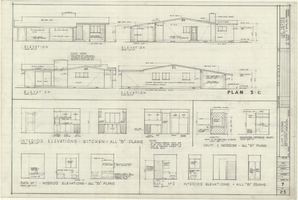
Architectural drawings of residential home in Las Vegas, Nevada, exterior elevations, May 23, 1958
Date
Archival Collection
Description
Exterior and interior elevations of a ranch-style residential home in the Las Verdes Heights development in Las Vegas, Nevada. Interior elevations for kitchen, bathrooms and vanity and wardrobe shown. "Drawn by J.C.M. Checked by E.C.B." "Sheet no. 7 of 25."
Site Name: Las Verdes Heights
Image