Search Results
Utah territory volume six, divisions one through five tax lists, 1868 to 1869
Level of Description
File
Archival Collection
UNLV Libraries Collection of Utah Territorial Assessment Records
To request this item in person:
Collection Number: MS-01026
Collection Name: UNLV Libraries Collection of Utah Territorial Assessment Records
Box/Folder: Oversized Box 01
Collection Name: UNLV Libraries Collection of Utah Territorial Assessment Records
Box/Folder: Oversized Box 01
Archival Component
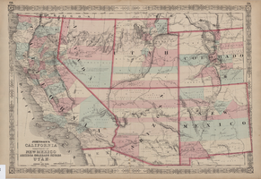

Map of California, and territories of Utah, Nevada, Colorado, New Mexico and Arizona, 1864
Date
1864
Description
'Johnson's California, also Utah, Nevada, Colorado, New Mexico, and Arizona, published by A.J. Johnson, New York.' 'Entered according to act of Congress in the year 1864, by A.J. Johnson in the Clerks Office of the District Court of the United States for the southern district of New York.' Atlas page numbers in upper margin: 67-68. Relief shown by hachures. Prime meridian: Greenwich and Washington. Shows natural features, locations of Indian tribes, proposed railroad routes, routes of explorers, trails, county boundaries and populated places. Hand colored. On verso: 'Historical and statistical view of the West India Islands or Columbian Archipelago' (p. 80) and 'Historical and statistical view of Mexico and Central America' (p. 79). Scale [ca. 1:3,484,800]. 1 in. to ca. 55 miles (W 124°--W 102°/N 42°--N 32°).
Text
"Start the Presses: the Birth of Journalism in Washington Territory" published doctoral dissertation by Barbara Cloud, 1979
Level of Description
File
Archival Collection
Barbara Cloud Personal Papers
To request this item in person:
Collection Number: MS-01085
Collection Name: Barbara Cloud Personal Papers
Box/Folder: Box 01
Collection Name: Barbara Cloud Personal Papers
Box/Folder: Box 01
Archival Component
International Stewards and Caterers Association Eastern Territorial Conference, Hotel Somerset, Boston, Massachusetts , 1951
Level of Description
File
Archival Collection
International Food Service Executives Association Records
To request this item in person:
Collection Number: MS-00305
Collection Name: International Food Service Executives Association Records
Box/Folder: Box 049
Collection Name: International Food Service Executives Association Records
Box/Folder: Box 049
Archival Component
Reproduction of a 1786 decree electing Joseph II as Emperor of all Roman held territories, undated
Level of Description
File
Archival Collection
S. R. Shapiro Collection
To request this item in person:
Collection Number: MS-00085
Collection Name: S. R. Shapiro Collection
Box/Folder: Oversized Box SH-079
Collection Name: S. R. Shapiro Collection
Box/Folder: Oversized Box SH-079
Archival Component
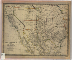
Map of Utah, New Mexico, Texas, California, Indian territory, and the northern states of Mexico, 1852
Date
1852-01-01
Description
At head of title: 'North America, sheet XV.' 'Published under the superintendence of the Society for Diffusion of Useful Knowledge.' At bottom center of map:'London, Charles Knight, Jany. 1st, 1852.' At bottom right of map: ' J. & C. Walker Sculpt.' Scale [1:7,500,000] 1 degree to 68.89 English miles (W 125°--W 92°/N 43°30?--N 22°30?). Relief shown by hachures. Atlas page number in lower margin: 144. Boundaries hand colored. Includes notes, locations of Indian tribes, population statistics. Charles Knight.
Image
U.S. Territory Western Region: A Regional and Economic Review and Forecast, 1998
Level of Description
File
Archival Collection
Patrick Egger Southern Nevada Real Estate Records
To request this item in person:
Collection Number: MS-00878
Collection Name: Patrick Egger Southern Nevada Real Estate Records
Box/Folder: Box 59
Collection Name: Patrick Egger Southern Nevada Real Estate Records
Box/Folder: Box 59
Archival Component
Desk used by Mark Twain while editor of the Territorial Enterprise: postcard, approximately 1975
Level of Description
Item
Archival Collection
Nan Doughty Photograph Collection
To request this item in person:
Collection Number: PH-00240
Collection Name: Nan Doughty Photograph Collection
Box/Folder: Folder 10
Collection Name: Nan Doughty Photograph Collection
Box/Folder: Folder 10
Archival Component